16 Oct Rain Shadow
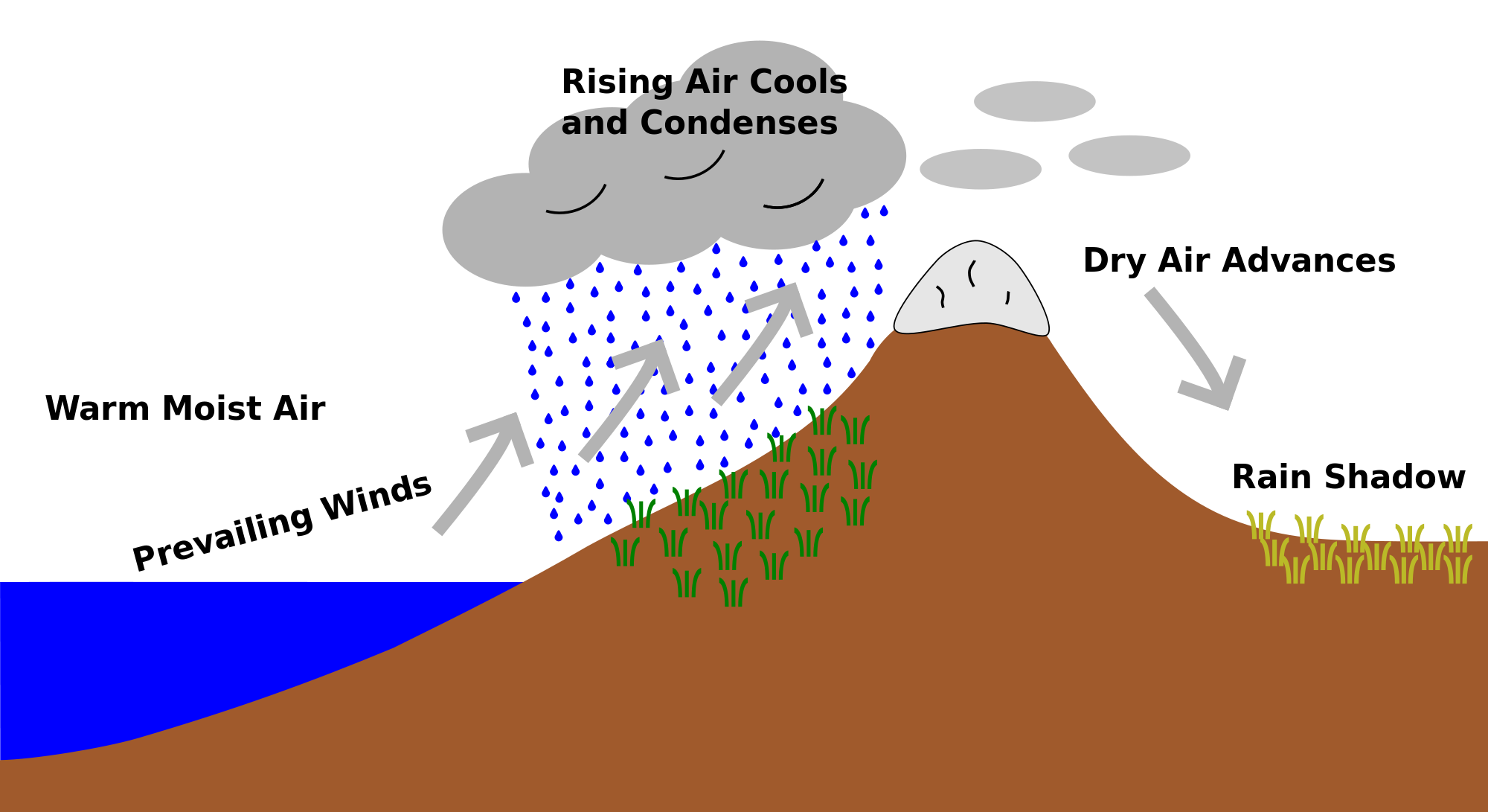
Rain shadows are related to and caused by orographic lifting. The process causes the opposite effects of rainfall by orographic lifting, on the opposite side of the mountain rain and as a result, rain shadows are renowned for producing some of the driest climates on planet Earth. Luckily, Australia doesn’t experience harsh rain shadow and this is largely due to the way our Country is shaped, however we do still experience them and in more ways than one.
So what are rain shadows, how do they occur and how do they impact Australia?
A ‘rain shadow’ is the dry area on the leeward side (the side away from the wind) on a mountainous area. The orographic lift effect forces moisture up one side of the mountain, where it then cools and condenses on that same side. A rain shadow occurs when this takes place and the mountains whilst producing rainfall also block rainfall from occur on the other side and therefore the name “rain shadow” is adopted as the mountain is casting a shadow of dryness over one side of the mountain. The leeward side of the mountain can also be remarkably hot as the sea breeze becomes blocked and humidity levels plummet.
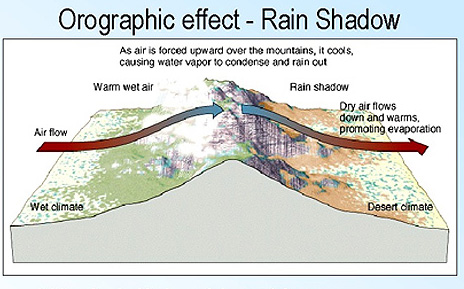
Illustration of how a rain shadow works
Rain shadows are renowned globally for producing some of the driest areas on the planet, and while the list is far too long to describe every single one of them.. there are some highlights from the list which are remarkable.
-
The Himalayan Mountains contribute to arid conditions across Central Asia including the Gobi Desert in Mongolia
-
The Arakan Mountains in Myanmar create a phenomenal difference… 750mm of rain occurs annually across Central Myanmar, whereas on the Rakhine Coast (the opposite side of the Mountains) more than 5500mm of rain occurs annually
-
The Judaean Hills in the Middle East are responsible for the Judaean Desert, Dead Sea and the Western slopes of the Moab Mountains.
-
The Atacama Desert in Chile is the driest non-polar desert on Earth due to the Andes Mountains blocking moisture
-
South-Western parts of Hispaniola, Cuba and Jamaica are in the rain shadow of the trade winds and can receive less as little as 400mm per year compared to the North-Western sides who see more than 2000mm per year and the Highlands who can see as much as 5000mm per year!
-
Death Valley, the worlds hottest location, is located behind the Pacific Coast Ranges and the Sierra Nevada Range. Its the driest place in North America.
-
Yellowknife, the most populated city in North-Western Canada, is located in the rain shadow of the Ranges to the West
-
San Jose and adjacent cities are usually drier than the rest of the San Francisco Bay area due to the Santa Cruz Mountains
-
The valley of the Vardar River and south from Skopje to Athens is in the rain shadow of the Prokletije and Pindus Mountains. On its windward side the Prokletije has the highest rainfall in Europe at around 5,000mm with small glaciers even at mean annual temperatures well above 0 °C, but the leeward side receives as little as 400mm.
-
Hawaii may see the biggest rain shadow of the lot, with an entire island in the rain shadow of another island. The island of Kauai records on average, 12,700mm of rain per year due to orographic lifting yet on the Leeward side of the East Maui Volcano, the Island of Kahoolawe is virtually desert.
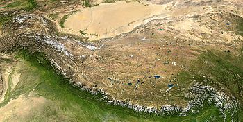
The Tibetan Plateau is probably the best example of a rain shadow around the world
There are 4 known official rain shadows within Australia however they arent as significant as those above
-
The Central Midlands of Tasmania receives about 20% of the rainfall than areas West of the Ranges including Mount Read
-
Monaro is shielded by the Snowy Mountains in both VIC and NSW
-
The Western side of Port Phillip Bay in Victoria is shielded by the Otway Ranges. The area between Geelong and Werribee is the driest area in Victoria yet the Otway’s record on average 2000mm per year.
-
In Western Australia, the Great Southern regions are shielded by the Darling Range. Dwellingup records on average 1000mm per year, with Narrogin around 130km to the East of Dwellingup, seeing just 500mm per year.
So whats the other way we experience them in Australia?
Rain shadows can also be evident through the snow version of them also. While not many areas receive snowfall in Australia, there are some that miss out due to Rain Shadows (or I guess snow shadows in this case). Snowfall occurs down to low levels in Southern Tasmania every year, however due to the way the systems move through, its common for Hobart and more importantly the Highlands of Hobart to miss out. These areas are usually much higher than the forecast snow levels, however Mt Wellington casts a shadow over the region. The same occurs in Canberra where the odd system may produce snow below Canberra’s elevation but the Brindabella Ranges to the West and Snowy Mountains to the South-West cast a shadow over the majority of the ACT and inevitably Canberra.
Why this occurs is the same process where dry air becomes trapped over the leeward side of the Ranges, so while the temperatures are perfectly adequate for snow to occur not only in those areas, but much lower.. the moisture level is shocking and precipitation struggles let alone snowfall.
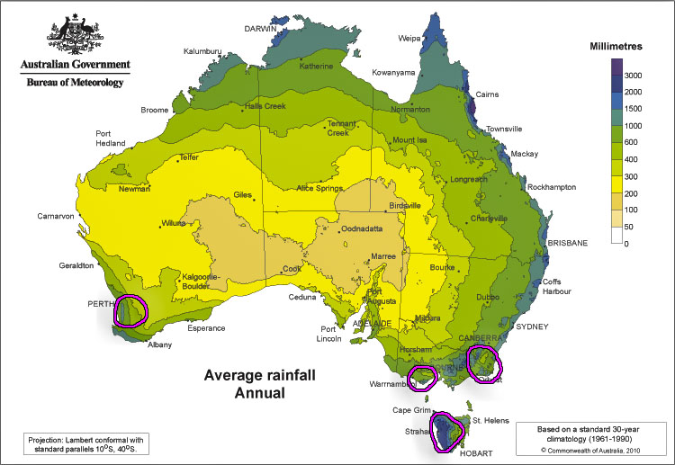
Areas in Australia impacted by Rain Shadows via BOM
Sorry, the comment form is closed at this time.