South East QLD Daily Forecast
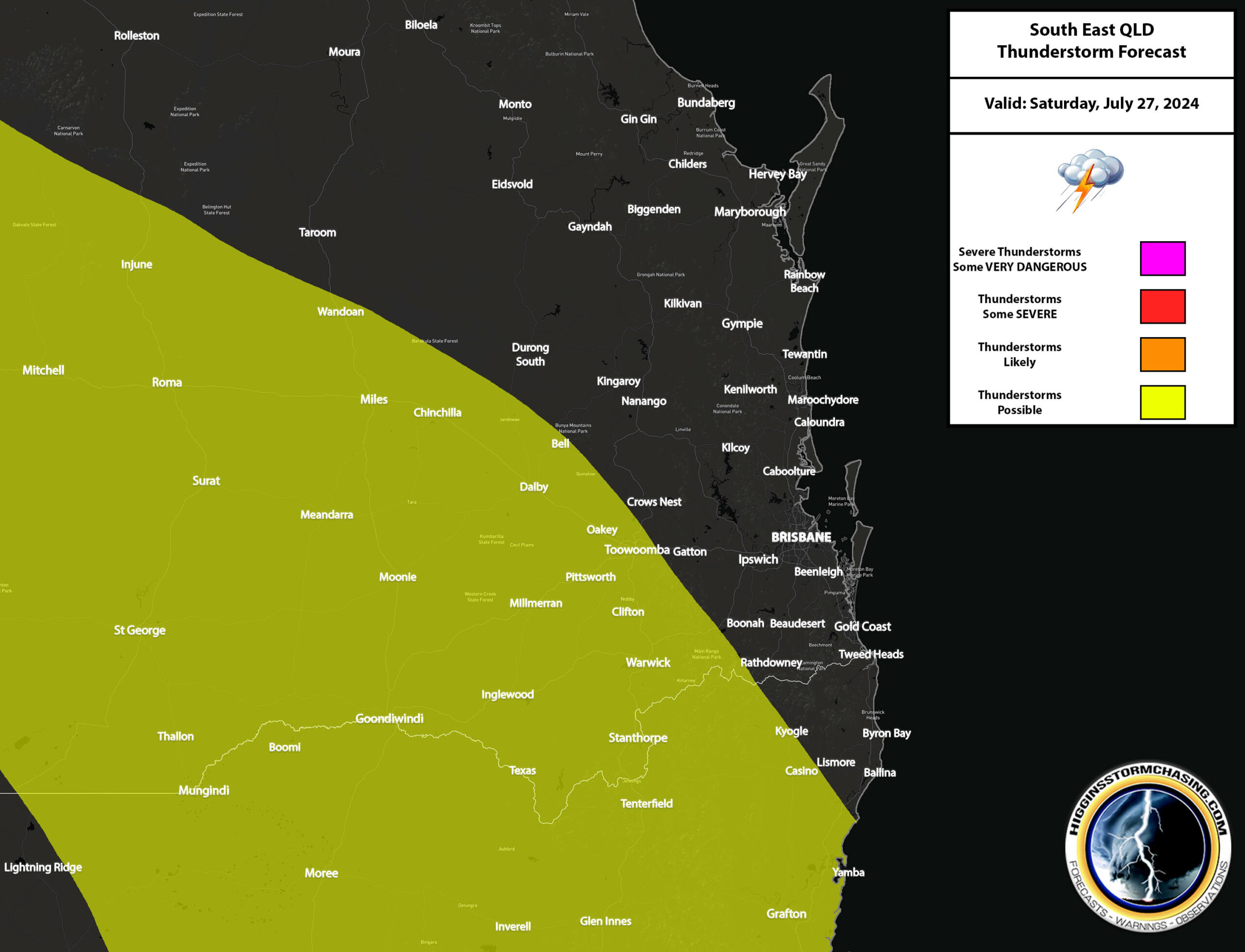
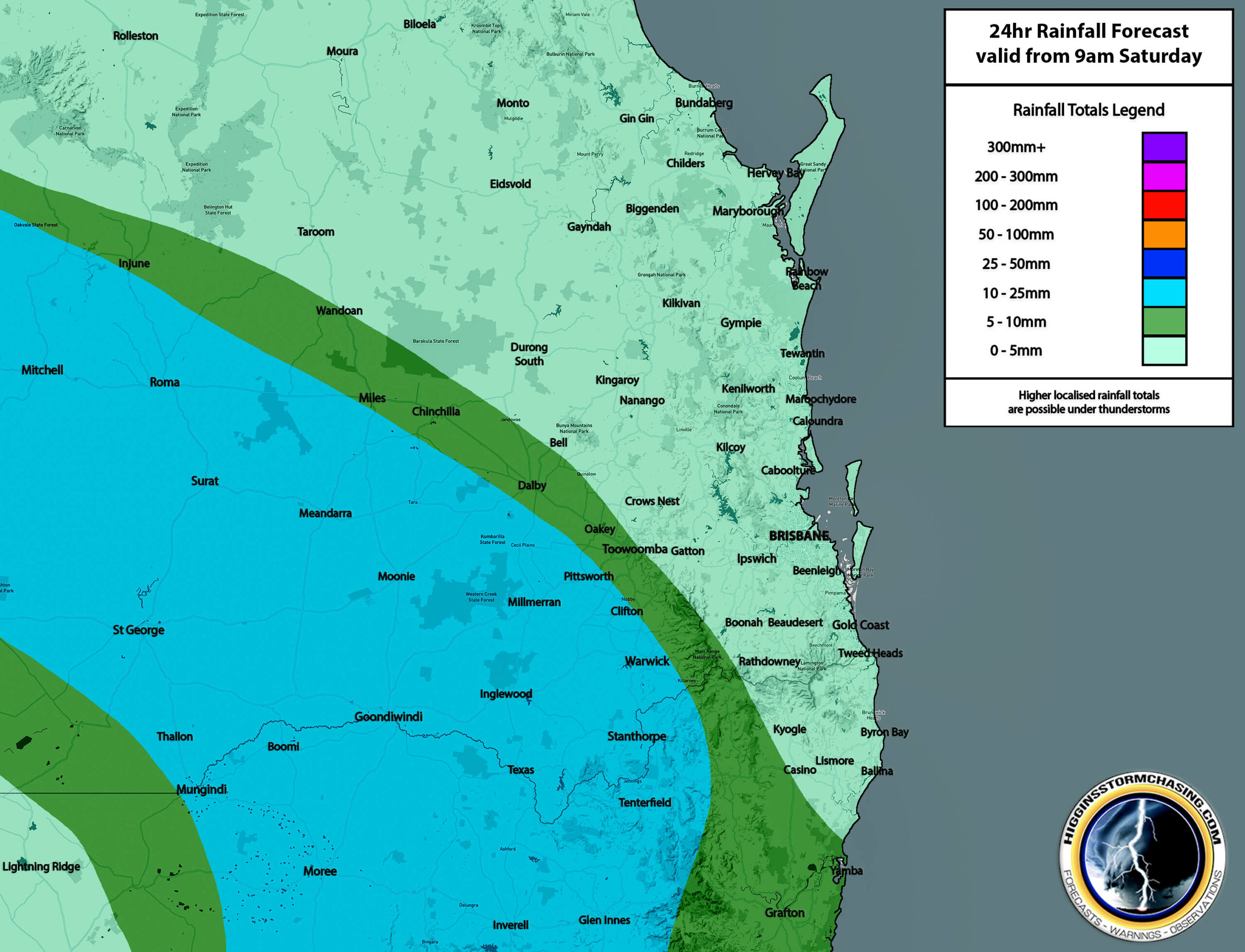
Saturday 27th of July 2024
A large surface trough is expected to be situated across the Southern Downs / Granite Belt, Darling Downs, Warrego & Maranoa during the morning and into the afternoon, before this surface trough eventually pushes through to the Coastline during the overnight hours of Saturday into Sunday. This trough is expected to continue to draw in very warm and somewhat humid air had of it with Easterly winds offshore veering more North to North Westerly ahead of the trough over land areas. These winds will combine with some increased upper level support in the wake of the trough to produce a thick band of showers, light to locally moderate rain areas and some possible embedded storms across Inland areas of the forecast region during the morning, afternoon, evening and night – with activity very slowly progressing towards Coastal areas. Any storms that do develop within these rain areas may contain locally heavier rainfall, some gusty winds and/or possible small hail.
Across the South East Coast, Wide Bay & Burnett, some isolated, patchy, hit and miss showers are possible during the day, however most of the rain chances are expected to occur during the overnight hours of Saturday into Sunday when the system eventually pushes through. By this time however, the system may be starting to weaken, leading to reduced impacts.
Temperatures: Brisbane 13-26ºc, Ipswich 8-27ºc, Beaudesert 9-26ºc, Gold Coast Seaway 14-24ºc, Gold Coast Inland 10-26ºc, Coolangatta 13-24ºc, Sunshine Coast 12-25ºc, Gympie 9-25ºc, Hervey Bay 13-23ºc, Maryborough 10-25ºc, Kingaroy 6-23ºc, Bundaberg 13-24ºc, Gayndah 10-26ºc, Gatton 9-26ºc, Toowoomba 9-22ºc, Warwick 7-22ºc, Dalby 7-24ºc, Stanthorpe 7-18ºc, Goondiwindi 10-22ºc, Roma 9-25ºc, St George 12-22ºc.
Sunday 28th of July 2024
Moderate to strong South West to Westerly winds are expected to impact the South East Coast, Wide Bay & Burnett, Darling Downs and Granite Belt during the day, with these winds becoming slightly more South to South Westerly across Western parts of the forecast region. These winds are expected to contain drier air – which will likely lead to widespread fine and sunny conditions across all areas… with the gusty nature of the winds making it feel even cooler.
Temperatures: Brisbane 15-23ºc, Ipswich 12-23ºc, Beaudesert 11-23ºc, Gold Coast Seaway 15-23ºc, Gold Coast Inland 12-23ºc, Coolangatta 13-23ºc, Sunshine Coast 14-23ºc, Gympie 12-23ºc, Hervey Bay 13-23ºc, Maryborough 13-24ºc, Kingaroy 9-20ºc, Bundaberg 15-23ºc, Gayndah 12-23ºc, Gatton 12-22ºc, Toowoomba 11-16ºc, Warwick 9-18ºc, Dalby 8-19ºc, Stanthorpe 8-15ºc, Goondiwindi 9-18ºc, Roma 8-19ºc, St George 8-17ºc.

Monday 29th of July 2024
South Westerly winds are expected to dominate the entire forecast region throughout the day. These winds are expected to draw in some drier air aloft, which will likely lead to widespread fine and sunny conditions across the entire forecast region throughout the day. The combination of drier air and lighter winds will also likely lead to widespread morning frost across Inland areas, and Interior parts of the South East Coast, Wide Bay & Burnett.
Temperatures: Brisbane 8-21ºc, Ipswich 2-21ºc, Beaudesert 4-20ºc, Gold Coast Seaway 9-19ºc, Gold Coast Inland 3-20ºc, Coolangatta 7-19ºc, Sunshine Coast 8-21ºc, Gympie 6-22ºc, Hervey Bay 8-20ºc, Maryborough 7-22ºc, Kingaroy 1-18ºc, Bundaberg 8-22ºc, Gayndah 4-22ºc, Gatton 4-20ºc, Toowoomba 2-14ºc, Warwick -1ºc to 17ºc, Dalby -1ºc to 17ºc, Stanthorpe -1ºc to 14ºc, Goondiwindi -1ºc to 16ºc, Roma -1ºc to 16ºc, St George 1-16ºc.
Extended forecast for Tuesday 30th of July to Thursday 1st of August
During Tuesday, widespread fine and sunny conditions are likely over the entire forecast region. During Wednesday, widespread fine and sunny conditions are likely over the entire forecast region. During Thursday, widespread fine and sunny conditions are likely over the entire forecast region.
Flood Risk Map
There are currently no flood threats across SEQLD.
NOTE: Our forecasts and maps are accurately produced using the data assimilation process of various global models. They are not copied nor reproduced from any other weather agency or source. All information behind the subscription paywall must NOT be shared to any third parties without express permission.