03 Oct Tornado
[fusion_builder_container background_color=”” background_image=”” background_parallax=”none” enable_mobile=”no” parallax_speed=”0.3″ background_repeat=”no-repeat” background_position=”left top” video_url=”” video_aspect_ratio=”16:9″ video_webm=”” video_mp4=”” video_ogv=”” video_preview_image=”” overlay_color=”” video_mute=”yes” video_loop=”yes” fade=”no” border_color=”” border_style=”” padding_top=”20″ padding_bottom=”20″ padding_left=”” padding_right=”” hundred_percent=”no” equal_height_columns=”no” hide_on_mobile=”no” menu_anchor=”” class=”” id=”” type=”legacy” border_sizes_top=”0px” border_sizes_bottom=”0px” border_sizes_left=”0px” border_sizes_right=”0px”][fusion_builder_row][fusion_builder_column type=”1_1″ layout=”1_1″ background_position=”left top” background_color=”” border_color=”” border_style=”solid” spacing=”yes” background_image=”” background_repeat=”no-repeat” padding_top=”” padding_right=”” padding_bottom=”” padding_left=”” margin_top=”0px” margin_bottom=”0px” class=”” id=”” animation_type=”” animation_speed=”0.3″ animation_direction=”left” hide_on_mobile=”no” center_content=”no” min_height=”none” last=”true” hover_type=”none” link=”” border_position=”all” align_self=”flex-start” border_sizes_top=”” border_sizes_bottom=”” border_sizes_left=”” border_sizes_right=”” first=”true”][fusion_text]
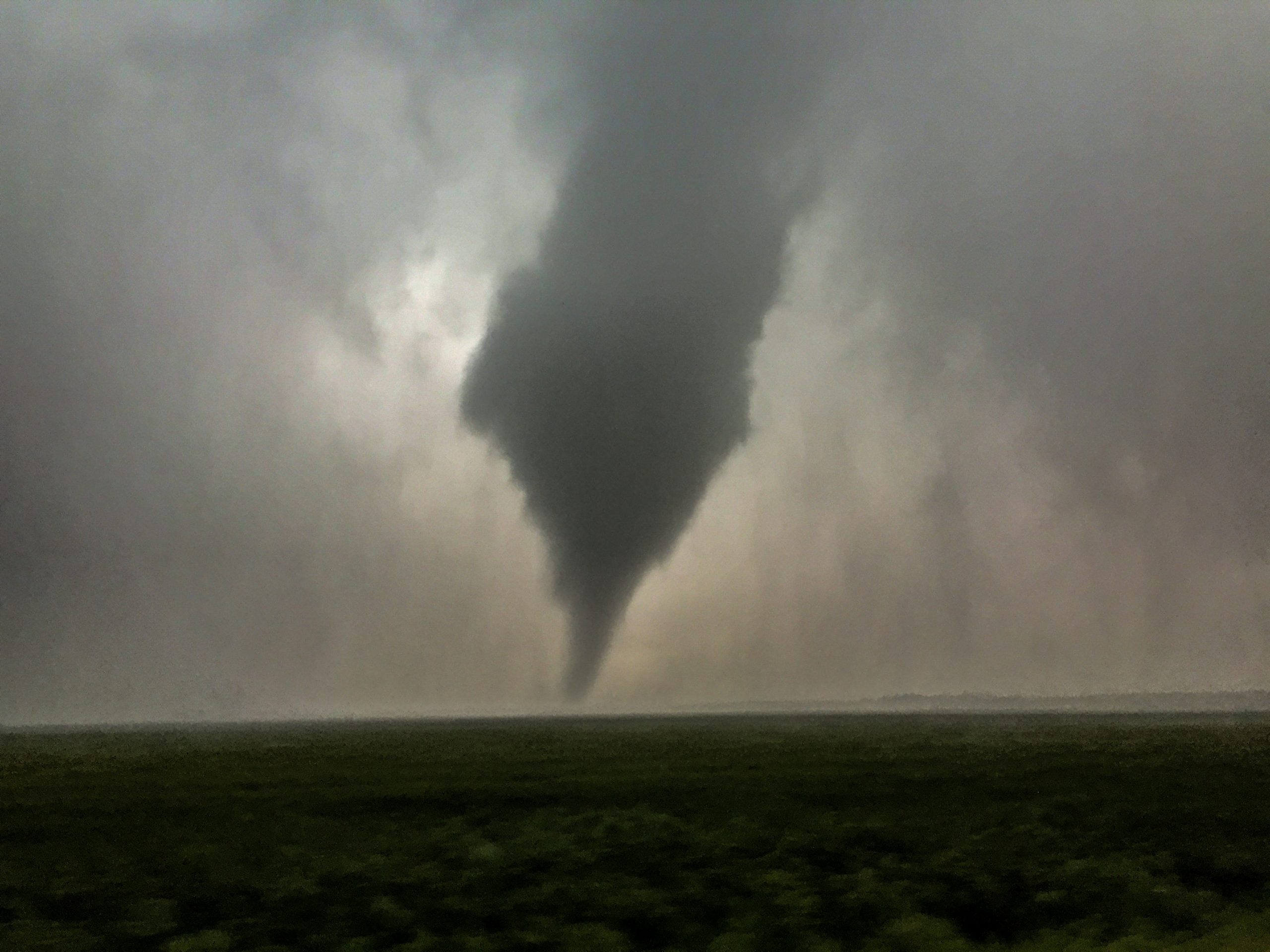
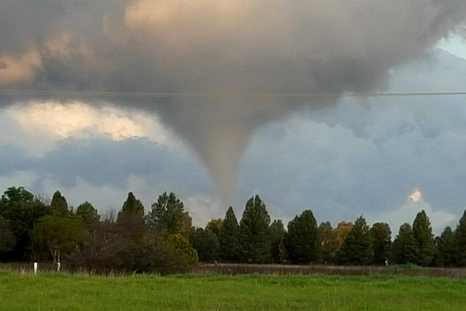
This is a write up describing what tornadoes are and how they occur, their relevance to Australia, the damage they can do and cause, along with busting some myths and highlighting some of Australia’s deadliest, most destructive and famous tornadoes and tornado related events. Above image: Tornado captured in Colorado by HSC Admin Thomas in 2015
[/fusion_text][fusion_text]
What is a Tornado and How do Tornadoes occur?
To put it simply, Tornadoes are strong to violently rotating columns of air which are attached to an associated Thunderstorm (Cumulonimbus Cloud). Tornadoes form under rare circumstances, especially in Australia. They occur as a result of a rare chain of events and this chain of events requires absolute precision for a tornado to occur. A supercell thunderstorm in about 99% of cases needs to be present. This rotating thunderstorm (mesocyclone) in simplistic terms has a strong moisture and heat feed which wraps around the backside of the Supercell due to the immense rotation, and this collides with a Rear Flank Downdraft (RFD). This collision creates a localised tightening of rotation within the cell and this produces a funnel cloud. As the tightening strengthens this funnel cloud may touch the ground – at which point a tornado is born.
[/fusion_text][fusion_separator style_type=”none” top_margin=”” bottom_margin=”” sep_color=”” border_size=”” icon=”” icon_circle=”” icon_circle_color=”” width=”” alignment=”” class=”” id=”” /][/fusion_builder_column][fusion_builder_column type=”1_1″ layout=”1_1″ background_position=”left top” background_color=”” border_color=”” border_style=”solid” spacing=”yes” background_image=”” background_repeat=”no-repeat” padding_top=”” padding_right=”” padding_bottom=”” padding_left=”” margin_top=”0px” margin_bottom=”0px” class=”” id=”” animation_type=”” animation_speed=”0.3″ animation_direction=”left” hide_on_mobile=”no” center_content=”no” min_height=”none” last=”true” hover_type=”none” link=”” border_position=”all” align_self=”flex-start” border_sizes_top=”” border_sizes_bottom=”” border_sizes_left=”” border_sizes_right=”” first=”true”][fusion_youtube id=”mclPB06sCYY” width=”600″ height=”350″ autoplay=”no” api_params=”” class=”” /][fusion_separator style_type=”none” top_margin=”” bottom_margin=”” sep_color=”” border_size=”” icon=”” icon_circle=”” icon_circle_color=”” width=”” alignment=”” class=”” id=”” /][fusion_separator style_type=”none” top_margin=”” bottom_margin=”” sep_color=”” border_size=”” icon=”” icon_circle=”” icon_circle_color=”” width=”” alignment=”” class=”” id=”” /][fusion_text]
There are also other types of tornadoes which occur due to differing circumstances. A waterspout is essentially a tornado over water – as soon as a waterspout comes ashore it is automatically a conventional tornado. One of the most famous Australian waterspouts was a very large one off Batemans Bay in NSW, while Lennox Head in Northern NSW had one come ashore causing significant damage. A common misconception about waterspouts is that they suck up water – this is false. They are rotating columns of air over water.
The other type of Tornado is a landspout tornado. This is essentially the name given to a tornado which doesn’t form due to a mesocyclone or rotating thunderstorm being present. They appear to be most common around drier areas.
[/fusion_text][/fusion_builder_column][fusion_builder_column type=”1_2″ layout=”1_2″ last=”false” spacing=”yes” center_content=”no” hide_on_mobile=”no” background_color=”” background_image=”” background_repeat=”no-repeat” background_position=”left top” hover_type=”none” link=”” border_position=”all” border_color=”” border_style=”” padding_top=”” padding_right=”” padding_bottom=”” padding_left=”” margin_top=”” margin_bottom=”” animation_type=”” animation_direction=”” animation_speed=”0.1″ animation_offset=”” class=”” id=”” min_height=”” border_sizes_top=”0px” border_sizes_bottom=”0px” border_sizes_left=”0px” border_sizes_right=”0px” first=”true” spacing_right=”2%”][fusion_text]

View of the Lennox Head Tornado / Waterspout as it destroys dozens of homes during the morning. Image Credit: Ross Tuckerman
[/fusion_text][/fusion_builder_column][fusion_builder_column type=”1_2″ layout=”1_2″ last=”true” spacing=”yes” center_content=”no” hide_on_mobile=”no” background_color=”” background_image=”” background_repeat=”no-repeat” background_position=”left top” hover_type=”none” link=”” border_position=”all” border_color=”” border_style=”” padding_top=”” padding_right=”” padding_bottom=”” padding_left=”” margin_top=”” margin_bottom=”” animation_type=”” animation_direction=”” animation_speed=”0.1″ animation_offset=”” class=”” id=”” min_height=”” border_sizes_top=”0px” border_sizes_bottom=”0px” border_sizes_left=”0px” border_sizes_right=”0px” first=”false” spacing_left=”2%”][fusion_text]
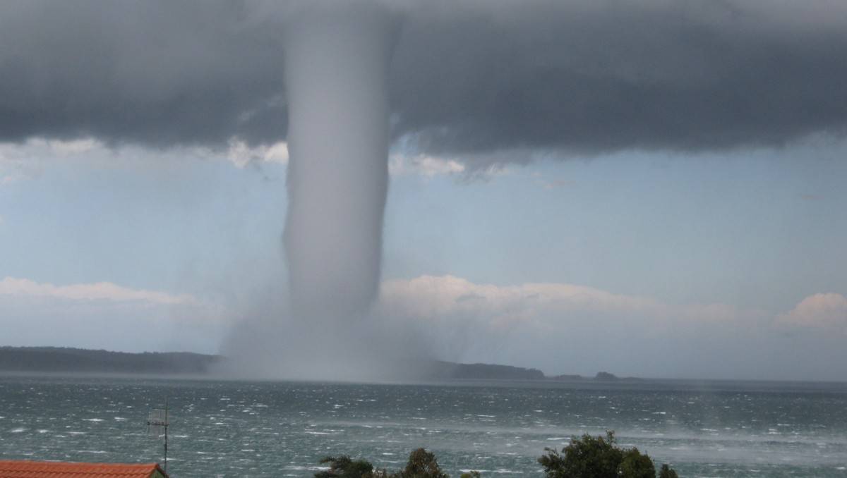
Giant waterspout offshore from Batemans Bay. Image Credit: Len Tompkins
[/fusion_text][/fusion_builder_column][fusion_builder_column type=”1_1″ layout=”1_1″ background_position=”left top” background_color=”” border_color=”” border_style=”solid” spacing=”yes” background_image=”” background_repeat=”no-repeat” padding_top=”” padding_right=”” padding_bottom=”” padding_left=”” margin_top=”0px” margin_bottom=”0px” class=”” id=”” animation_type=”” animation_speed=”0.3″ animation_direction=”left” hide_on_mobile=”no” center_content=”no” min_height=”none” last=”true” hover_type=”none” link=”” border_position=”all” align_self=”flex-start” border_sizes_top=”” border_sizes_bottom=”” border_sizes_left=”” border_sizes_right=”” first=”true”][fusion_text][wp_ad_camp_1][/fusion_text][fusion_text]
Where do Tornadoes occur?
The United States is clearly famous for tornadoes, with more than 1100 occurring per year on average. This is of course highlighted further by Tornado Alley. Other areas include:
-
Argentina / Uruguay (approx 300 per year)
-
Europe (approx 300 per year – UK has the highest number of tornadoes per square km globally)
-
Canada (approx 100 per year)
-
South Africa
-
Bangladesh / India and China, Japan, Philippines during Typhoon / Monsoon season
-
Australia and New Zealand (approx 20 per year in Australia but this number is growing)
In Australia, tornadoes are more common across the Eastern States, Eastern/South-East South Australia and Southern/Western WA. This is due to the more favourable tornadic conditions occurring more regularly through these regions. As a brief description, tornadoes are more common across NSW/QLD due to the shear number of severe storm setups that occur, while in VIC, Southern NSW, SE SA and Southern WA the combination of frequent close range lows / cold fronts along with the addition of the Snowy Mountains creating localised influences has lead to many touchdowns as these areas over recent years have charged ahead of QLD/NSW in terms of frequency.
[/fusion_text][/fusion_builder_column][fusion_builder_column type=”1_1″ layout=”1_1″ last=”true” spacing=”yes” center_content=”no” hide_on_mobile=”no” background_color=”” background_image=”” background_repeat=”no-repeat” background_position=”left top” hover_type=”none” link=”” border_position=”all” border_color=”” border_style=”” padding_top=”” padding_right=”” padding_bottom=”” padding_left=”” margin_top=”” margin_bottom=”” animation_type=”” animation_direction=”” animation_speed=”0.1″ animation_offset=”” class=”” id=”” min_height=”” border_sizes_top=”0px” border_sizes_bottom=”0px” border_sizes_left=”0px” border_sizes_right=”0px” first=”true”][fusion_text]
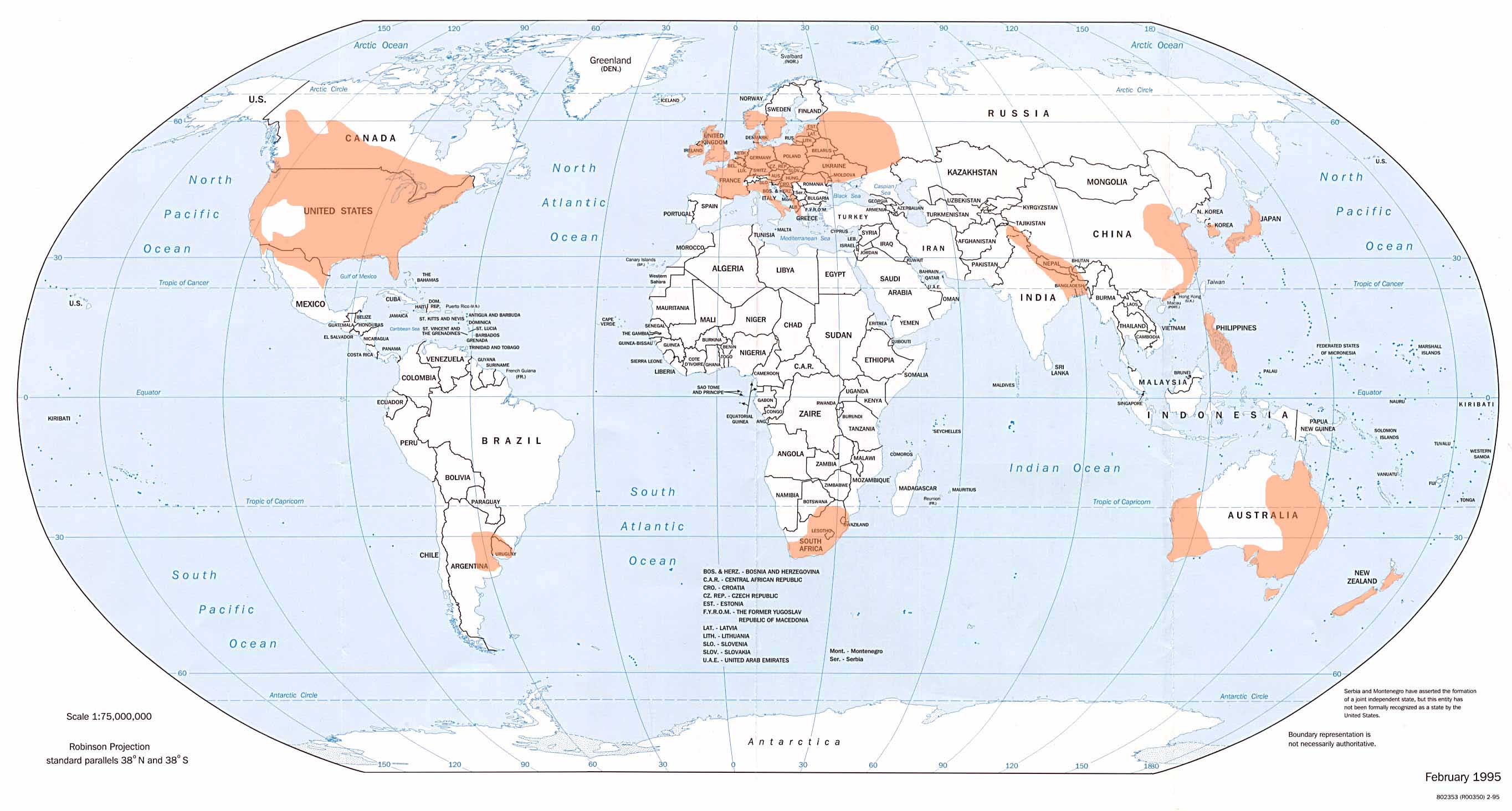
Global distribution of more Tornadoes
[/fusion_text][/fusion_builder_column][fusion_builder_column type=”1_1″ layout=”1_1″ background_position=”left top” background_color=”” border_color=”” border_style=”solid” spacing=”yes” background_image=”” background_repeat=”no-repeat” padding_top=”” padding_right=”” padding_bottom=”” padding_left=”” margin_top=”0px” margin_bottom=”0px” class=”” id=”” animation_type=”” animation_speed=”0.3″ animation_direction=”left” hide_on_mobile=”no” center_content=”no” min_height=”none” last=”true” hover_type=”none” link=”” border_position=”all” align_self=”flex-start” border_sizes_top=”” border_sizes_bottom=”” border_sizes_left=”” border_sizes_right=”” first=”true”][fusion_text columns=”” column_min_width=”” column_spacing=”” rule_style=”default” rule_size=”” rule_color=”” content_alignment_medium=”” content_alignment_small=”” content_alignment=”” hide_on_mobile=”small-visibility,medium-visibility,large-visibility” sticky_display=”normal,sticky” class=”” id=”” font_size=”” fusion_font_family_text_font=”” fusion_font_variant_text_font=”” line_height=”” letter_spacing=”” text_color=”” animation_type=”” animation_direction=”left” animation_speed=”0.3″ animation_offset=””][/fusion_text][fusion_text]
Tornado Rating and its Damage Potential:
A tornado is rated under the Enhanced Fujita Scale (which is where the term ‘EF’ comes from). The numbers are scaled from 0 to 5, with 0 being the weakest and 5 being the strongest. Under the old system of the Fujita Scale – tornadoes were measured through windspeed with some alterations due to damage, however in 2007 the Fujita scale was replaced by the Enhanced Fujita scale which measures the tornado’s strength through damage rather than wind speeds.
[/fusion_text][/fusion_builder_column][fusion_builder_column type=”1_1″ layout=”1_1″ last=”true” spacing=”yes” center_content=”no” hide_on_mobile=”no” background_color=”” background_image=”” background_repeat=”no-repeat” background_position=”left top” hover_type=”none” link=”” border_position=”all” border_color=”” border_style=”” padding_top=”” padding_right=”” padding_bottom=”” padding_left=”” margin_top=”” margin_bottom=”” animation_type=”” animation_direction=”” animation_speed=”0.1″ animation_offset=”” class=”” id=”” min_height=”” border_sizes_top=”0px” border_sizes_bottom=”0px” border_sizes_left=”0px” border_sizes_right=”0px” first=”true”][fusion_text]

Tornado damage ratings via NOAA
[/fusion_text][/fusion_builder_column][fusion_builder_column type=”1_1″ layout=”1_1″ background_position=”left top” background_color=”” border_color=”” border_style=”solid” spacing=”yes” background_image=”” background_repeat=”no-repeat” padding_top=”” padding_right=”” padding_bottom=”” padding_left=”” margin_top=”0px” margin_bottom=”0px” class=”” id=”” animation_type=”” animation_speed=”0.3″ animation_direction=”left” hide_on_mobile=”no” center_content=”no” min_height=”none” last=”true” hover_type=”none” link=”” border_position=”all” align_self=”flex-start” border_sizes_top=”” border_sizes_bottom=”” border_sizes_left=”” border_sizes_right=”” first=”true”][fusion_text columns=”” column_min_width=”” column_spacing=”” rule_style=”default” rule_size=”” rule_color=”” hide_on_mobile=”small-visibility,medium-visibility,large-visibility” class=”” id=””]
Some famous Australian Tornadoes / Tornado events:
-
Sydney, NSW (1795) – BOM’s first official record of a Tornado in Australia.
-
Marong, VIC (1911) – First official photograph of a Tornado. Wiped out the town of Lockwood.
-
Kin Kin, QLD (1971) – An EF-4 tornado killed 3 people, making it Australia’s deadliest Tornado to date.
-
Brisbane, QLD (1973) – A tornado touched down in Brisbane’s Inner West (Kenmore/Brookfield) before tracking through the City to Mt Gravatt and dissipating around Cleveland. This is known as one of Australia’s most costliest Tornadoes in history due to the path it took.
-
SEQ Tornado Outbreak (1989), a dangerous Supercell with tops to 77,000ft produced numerous tornadoes throughout its course – leaving a swath of destruction through Brisbane CBD, North Brisbane, Scenic Rim and Redcliffe.
-
Dunoon, NSW (2007) – a multi vortex tornado caused significant damage near Lismore.
-
Bacchus Marsh, VIC (2011) – A supercell thunderstorm produces a strong tornado on Christmas Day leaving a trail of destruction. The supercell went on to produce widespread hail in Melbourne CBD
-
Bargara, QLD (2013) – During Tropical Cyclone Oswald, 6 Tornadoes were confirmed to have touched down – 3 of which occurred at Bagara causing significant damage.
-
Sydney / Illawarra (2013) – Australia’s biggest single-day outbreak with 8 tornadoes touching down. Kiama, Albion Park, Nowra, Eastern Sydney (Kirribilli) were all amongst areas that had confirmed tornado damage. 2 EF-0 Tornadoes were confirmed, 5 EF-1 and 1 EF-2 (Kiama).
-
Eastern VIC (2013) – Just a month after Sydney’s outbreak, an outbreak of 7 tornadoes were confirmed in Eastern VIC. 1 was rated EF-4 (highest rated tornado in Australian history). This tornado hit Koonoomoo, Cobram, Barooga, Mulwala, Yarrawonga and Bundalong. The same Supercell produced a second tornado later on in Rutherglen. Several people were injured.
-
Kurnell, NSW (2015) – A violent tornado touched down in Kurnell, leading to the strongest recorded windspeed in NSW history and the damage of hundreds of homes.
-
South Australia Tornado Outbreak (2016) – At least 7 tornadoes were confirmed by the Bureau of Meteorology to touchdown, with many more potentially unconfirmed as a violent tornado outbreak took place across a large portion of South-Eastern South Australia. Amongst the 7 confirmed, were twin tornadoes which both hit the town of Blyth causing immense catastrophic damage. The tornadoes almost impacted many other towns along with downing the high voltage powerlines which run the State’s electricity supply – sending the ENTIRE state into a blackout. Click here for the BOM Summary
CLICK HERE TO BE REDIRECTED TO A LIST OF MANY TORNADOES TO HAVE TOUCHED DOWN IN AUSTRALIA
[/fusion_text][/fusion_builder_column][fusion_builder_column type=”1_2″ layout=”1_2″ last=”false” spacing=”yes” center_content=”no” hide_on_mobile=”no” background_color=”” background_image=”” background_repeat=”no-repeat” background_position=”left top” hover_type=”none” link=”” border_position=”all” border_color=”” border_style=”” padding_top=”” padding_right=”” padding_bottom=”” padding_left=”” margin_top=”” margin_bottom=”” animation_type=”” animation_direction=”” animation_speed=”0.1″ animation_offset=”” class=”” id=”” min_height=”” border_sizes_top=”0px” border_sizes_bottom=”0px” border_sizes_left=”0px” border_sizes_right=”0px” first=”true” spacing_right=”2%”][fusion_text columns=”” column_min_width=”” column_spacing=”” rule_style=”default” rule_size=”” rule_color=”” hide_on_mobile=”small-visibility,medium-visibility,large-visibility” class=”” id=””]
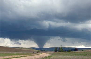
Tornado observed near Nimmitabel, Southern NSW in 2008. Image Credit: Heather Leckie
[/fusion_text][/fusion_builder_column][fusion_builder_column type=”1_2″ layout=”1_2″ last=”true” spacing=”yes” center_content=”no” hide_on_mobile=”no” background_color=”” background_image=”” background_repeat=”no-repeat” background_position=”left top” hover_type=”none” link=”” border_position=”all” border_color=”” border_style=”” padding_top=”” padding_right=”” padding_bottom=”” padding_left=”” margin_top=”” margin_bottom=”” animation_type=”” animation_direction=”” animation_speed=”0.1″ animation_offset=”” class=”” id=”” min_height=”” border_sizes_top=”0px” border_sizes_bottom=”0px” border_sizes_left=”0px” border_sizes_right=”0px” first=”false” spacing_left=”2%”][fusion_text]

First captured tornado at Marong, VIC 1911. Image released by the Victoria Museum
[/fusion_text][/fusion_builder_column][fusion_builder_column type=”1_2″ layout=”1_2″ last=”false” spacing=”yes” center_content=”no” hide_on_mobile=”no” background_color=”” background_image=”” background_repeat=”no-repeat” background_position=”left top” hover_type=”none” link=”” border_position=”all” border_color=”” border_style=”” padding_top=”” padding_right=”” padding_bottom=”” padding_left=”” margin_top=”” margin_bottom=”” animation_type=”” animation_direction=”” animation_speed=”0.1″ animation_offset=”” class=”” id=”” min_height=”” border_sizes_top=”0px” border_sizes_bottom=”0px” border_sizes_left=”0px” border_sizes_right=”0px” first=”true” spacing_right=”2%”][fusion_text]

Tornado captured in Monarto, South Australia in 2015. Image Credit: Lisa Bennier
[/fusion_text][/fusion_builder_column][fusion_builder_column type=”1_2″ layout=”1_2″ last=”true” spacing=”yes” center_content=”no” hide_on_mobile=”no” background_color=”” background_image=”” background_repeat=”no-repeat” background_position=”left top” hover_type=”none” link=”” border_position=”all” border_color=”” border_style=”” padding_top=”” padding_right=”” padding_bottom=”” padding_left=”” margin_top=”” margin_bottom=”” animation_type=”” animation_direction=”” animation_speed=”0.1″ animation_offset=”” class=”” id=”” min_height=”” border_sizes_top=”0px” border_sizes_bottom=”0px” border_sizes_left=”0px” border_sizes_right=”0px” first=”false” spacing_left=”2%”][fusion_text]
Ef-1 Tornado forming at Dubbo in 2015. Image Credit: David Daly
[/fusion_text][/fusion_builder_column][fusion_builder_column type=”1_1″ layout=”1_1″ background_position=”left top” background_color=”” border_color=”” border_style=”solid” spacing=”yes” background_image=”” background_repeat=”no-repeat” padding_top=”” padding_right=”” padding_bottom=”” padding_left=”” margin_top=”0px” margin_bottom=”0px” class=”” id=”” animation_type=”” animation_speed=”0.3″ animation_direction=”left” hide_on_mobile=”no” center_content=”no” min_height=”none” last=”true” hover_type=”none” link=”” border_position=”all” align_self=”flex-start” border_sizes_top=”” border_sizes_bottom=”” border_sizes_left=”” border_sizes_right=”” first=”true”][fusion_text]
Difference between Cyclone and a Tornado?
A cyclone is large low pressure system which produces heavy to torrential rainfall and damaging to destructive wind gusts across large areas. They are completely different weather phenomenons that occur under completely different weather setups.
Similarities: Cyclones and Tornadoes have a few things in common, they can both produce destructive winds leading to severe damage or pose a threat to life. Thats about it.
Differences: Tornadoes cover an area from the width of a street, to the width of a suburb (30-50m up to 4km), Cyclones range from 50km wide to 400km wide. A cyclone’s damaging wide range is far far greater than any Tornado. A tornado may last for a few seconds to several minutes or even an hour or two, while a Cyclone lasts anywhere from a few days to several weeks.
Whats a ‘Mini-Tornado’?
There is NO such thing as a ‘mini’ Tornado. Tornadoes are all the same – violent rotating columns of air attached to thunderstorms. The terminology has most likely occurred due to Australia not receiving the same level of destruction surrounding Tornadoes as America does. However, Tornadoes are measured by wind speeds and width… NOT height. Its either a Tornado or its not. Simple as that!
[/fusion_text][/fusion_builder_column][fusion_builder_column type=”1_1″ layout=”1_1″ last=”true” spacing=”yes” center_content=”no” hide_on_mobile=”no” background_color=”” background_image=”” background_repeat=”no-repeat” background_position=”left top” hover_type=”none” link=”” border_position=”all” border_color=”” border_style=”” padding_top=”” padding_right=”” padding_bottom=”” padding_left=”” margin_top=”” margin_bottom=”” animation_type=”” animation_direction=”” animation_speed=”0.1″ animation_offset=”” class=”” id=”” min_height=”” border_sizes_top=”0px” border_sizes_bottom=”0px” border_sizes_left=”0px” border_sizes_right=”0px” first=”true”][fusion_youtube id=”HURlLa1CFWo” width=”600″ height=”350″ autoplay=”no” api_params=”” class=”” /][/fusion_builder_column][fusion_builder_column type=”1_1″ layout=”1_1″ background_position=”left top” background_color=”” border_color=”” border_style=”solid” spacing=”yes” background_image=”” background_repeat=”no-repeat” padding_top=”” padding_right=”” padding_bottom=”” padding_left=”” margin_top=”0px” margin_bottom=”0px” class=”” id=”” animation_type=”” animation_speed=”0.3″ animation_direction=”left” hide_on_mobile=”no” center_content=”no” min_height=”none” last=”true” hover_type=”none” link=”” border_position=”all” align_self=”flex-start” border_sizes_top=”” border_sizes_bottom=”” border_sizes_left=”” border_sizes_right=”” first=”true”][fusion_separator style_type=”none” top_margin=”” bottom_margin=”” sep_color=”” border_size=”” icon=”” icon_circle=”” icon_circle_color=”” width=”” alignment=”” class=”” id=”” /][fusion_text columns=”” column_min_width=”” column_spacing=”” rule_style=”default” rule_size=”” rule_color=”” content_alignment_medium=”” content_alignment_small=”” content_alignment=”” hide_on_mobile=”small-visibility,medium-visibility,large-visibility” sticky_display=”normal,sticky” class=”” id=”” font_size=”” fusion_font_family_text_font=”Default” fusion_font_variant_text_font=”” line_height=”” letter_spacing=”” text_color=”” animation_type=”” animation_direction=”left” animation_speed=”0.3″ animation_offset=””][/fusion_text][/fusion_builder_column][/fusion_builder_row][/fusion_builder_container]


Sorry, the comment form is closed at this time.