02 Oct Supercell
[fusion_builder_container background_color=”” background_image=”” background_parallax=”none” enable_mobile=”no” parallax_speed=”0.3″ background_repeat=”no-repeat” background_position=”left top” video_url=”” video_aspect_ratio=”16:9″ video_webm=”” video_mp4=”” video_ogv=”” video_preview_image=”” overlay_color=”” video_mute=”yes” video_loop=”yes” fade=”no” border_color=”” border_style=”” padding_top=”20″ padding_bottom=”20″ padding_left=”” padding_right=”” hundred_percent=”no” equal_height_columns=”no” hide_on_mobile=”no” menu_anchor=”” class=”” id=”” type=”legacy” border_sizes_top=”0px” border_sizes_bottom=”0px” border_sizes_left=”0px” border_sizes_right=”0px”][fusion_builder_row][fusion_builder_column type=”1_1″ layout=”1_1″ background_position=”left top” background_color=”” border_color=”” border_style=”solid” spacing=”yes” background_image=”” background_repeat=”no-repeat” padding_top=”” padding_right=”” padding_bottom=”” padding_left=”” margin_top=”0px” margin_bottom=”0px” class=”” id=”” animation_type=”” animation_speed=”0.3″ animation_direction=”left” hide_on_mobile=”no” center_content=”no” min_height=”none” last=”true” hover_type=”none” link=”” border_position=”all” align_self=”flex-start” border_sizes_top=”” border_sizes_bottom=”” border_sizes_left=”” border_sizes_right=”” first=”true”][fusion_text]
The idea of this is to help explain and educate people on one of the most locally severe elements during an Australian storm season along with bringing attention to the integrity and relevance that Supercell’s have within Australian storms. Above image: Booker, Texas Supercell by Australian Storm Chaser – Brad Hannon, back in June 2014
[/fusion_text][fusion_text]
How a Supercell is formed?
A Supercell is a more enhanced version of your typical severe thunderstorm. The base of all Supercell’s is the same – they require the presence of a mesocyclone which is a very deep and constant rotating updraft. How this rotating updraft occurs is through the combination of wind shear and updraft strength. Wind shear will give the storm movement and direction, whilst at the same time creating an invisible horizontal vortex within the storm. If the updraft is strong enough, it can tilt this horizontal vortex and allow it to become more vertical within the storm. This action allows the thunderstorm to enter ‘Supercell mode’ where the presence of rotation becomes clearly visible and from a viewing perspective – you will be able to see the entire base of the Supercell begin to rotate while from a scientific or meteorological perspective, indicators on radar will become present in the form of a ‘couplet’. The presence of this updraft is also very vital as it allows the Supercell to have a clear inflow and outflow (or updraft / downdraft). The separation of these is vital in that it allows the storm to maintain life, strength and formation. The updraft will consist of an inflow and this carries both the heat and moisture which feeds the storm while the downdraft consists of the rain, wind and hail. If these cross over then the heat feed is cut and the cell weakens.
[/fusion_text][fusion_text]
Characteristics of a Supercell?
Each Supercell has the same characteristics, just some characteristics are more prominent in some over others. Thats where the terminology of LP, HP and Classic comes into play. In simplistic terms:
-
LP (Low-Precipitation) Supercell: These types of Supercells are more inflow dominant and from a viewing perspective have a very strongly titled updraft which can sometimes have a corkscrew appearance. These types of cells produce minimal precipitation (rain/hail)
-
HP (High-Precipitation) Supercell: These have noticeably much heavier precipitation and this makes them far more dangerous. Due to the excessively heavy precipitation, the rotation of the mesocyclone can cause the precipitation to wrap around the entire cell making dangerous elements such as Tornadoes hidden. They can also dump excessive amounts of rain in short periods of time leading to flash flooding. However they are also some of the most colourful storms going around.
-
Classic Supercell: This your typical Supercell that consists of heavy rain, large to very large hail and damaging to destructive wind gusts.
[/fusion_text][/fusion_builder_column][fusion_builder_column type=”1_1″ layout=”1_1″ last=”true” spacing=”yes” center_content=”no” hide_on_mobile=”no” background_color=”” background_image=”” background_repeat=”no-repeat” background_position=”left top” hover_type=”none” link=”” border_position=”all” border_color=”” border_style=”” padding_top=”” padding_right=”” padding_bottom=”” padding_left=”” margin_top=”” margin_bottom=”” animation_type=”” animation_direction=”” animation_speed=”0.1″ animation_offset=”” class=”” id=”” min_height=”” border_sizes_top=”0px” border_sizes_bottom=”0px” border_sizes_left=”0px” border_sizes_right=”0px” first=”true”][fusion_text]
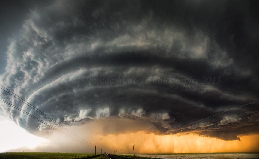
Characteristics of a Supercell looking towards it from the South-East in AUS
[/fusion_text][/fusion_builder_column][fusion_builder_column type=”1_1″ layout=”1_1″ background_position=”left top” background_color=”” border_color=”” border_style=”solid” spacing=”yes” background_image=”” background_repeat=”no-repeat” padding_top=”” padding_right=”” padding_bottom=”” padding_left=”” margin_top=”0px” margin_bottom=”0px” class=”” id=”” animation_type=”” animation_speed=”0.3″ animation_direction=”left” hide_on_mobile=”no” center_content=”no” min_height=”none” last=”true” hover_type=”none” link=”” border_position=”all” align_self=”flex-start” border_sizes_top=”” border_sizes_bottom=”” border_sizes_left=”” border_sizes_right=”” first=”true”][fusion_text columns=”” column_min_width=”” column_spacing=”” rule_style=”default” rule_size=”” rule_color=”” content_alignment_medium=”” content_alignment_small=”” content_alignment=”” hide_on_mobile=”small-visibility,medium-visibility,large-visibility” sticky_display=”normal,sticky” class=”” id=”” font_size=”” fusion_font_family_text_font=”” fusion_font_variant_text_font=”” line_height=”” letter_spacing=”” text_color=”” animation_type=”” animation_direction=”left” animation_speed=”0.3″ animation_offset=””]
As stated above, Supercells have notable characteristics. Some of them include:
-
Anvil Cloud: This is where the updraft reaches its the highest levels of the lowest part of the the atmosphere which is the Troposphere. Since it can no longer rise upwards, it spreads out. The anvil usually hangs out in front of the storm, or in other words – it faces the way the storm is moving. In some of the stronger updrafts though, back-sheared anvil can occur and this is where it can also overhang in the opposite direction to which the storm is moving.
-
Rain-Free Base (RFB): This is the main inflow area and is usually typified by a distinct lack of precipitation.
-
Wall Cloud: Wall clouds act as a barrier between the Rain-Free Base and the downdraft which consists of your precipitation. It forms through rain cooled air which becomes drawn in by the updraft. The cooler and wetter air is nurtured by the updraft forming a cloud which then continues to lower itself to the ground. Wall clouds are easy to spot if you’re facing the RFB as they show a box-like formation
-
Forward Flank Downdraft (FFD): These usually occurs in the heaviest precipitation areas. This downdraft pushes out from the Supercell, interacting with the warm and moist air outside of the cell to produce a shelf cloud which in turn, acts as a bound or visual feature separating the air outside of the cell from the precipitation inside the cell.
-
Rear Flank Downdraft (RFD): These usually occur on the back end of the Supercell and are typically associated with the RFB. This can play a vital role in the formation of tornadoes by tightening the already present rotation within the mesocyclone. They are derived from the mid level steering components of the Supercell which collide with the strong updraft. RFD winds can be some of the most violent straight line winds possible in thunderstorms.
[/fusion_text][/fusion_builder_column][fusion_builder_column type=”1_1″ layout=”1_1″ last=”true” spacing=”yes” center_content=”no” hide_on_mobile=”no” background_color=”” background_image=”” background_repeat=”no-repeat” background_position=”left top” hover_type=”none” link=”” border_position=”all” border_color=”” border_style=”” padding_top=”” padding_right=”” padding_bottom=”” padding_left=”” margin_top=”” margin_bottom=”” animation_type=”” animation_direction=”” animation_speed=”0.1″ animation_offset=”” class=”” id=”” min_height=”” border_sizes_top=”0px” border_sizes_bottom=”0px” border_sizes_left=”0px” border_sizes_right=”0px” first=”true”][/fusion_builder_column][fusion_builder_column type=”1_1″ layout=”1_1″ last=”true” spacing=”yes” center_content=”no” hide_on_mobile=”no” background_color=”” background_image=”” background_repeat=”no-repeat” background_position=”left top” hover_type=”none” link=”” border_position=”all” border_color=”” border_style=”” padding_top=”” padding_right=”” padding_bottom=”” padding_left=”” margin_top=”” margin_bottom=”” animation_type=”” animation_direction=”” animation_speed=”0.1″ animation_offset=”” class=”” id=”” min_height=”” border_sizes_top=”0px” border_sizes_bottom=”0px” border_sizes_left=”0px” border_sizes_right=”0px” first=”true”][fusion_text columns=”” column_min_width=”” column_spacing=”” rule_style=”default” rule_size=”” rule_color=”” content_alignment_medium=”” content_alignment_small=”” content_alignment=”” hide_on_mobile=”small-visibility,medium-visibility,large-visibility” sticky_display=”normal,sticky” class=”” id=”” font_size=”” fusion_font_family_text_font=”Default” fusion_font_variant_text_font=”” line_height=”” letter_spacing=”” text_color=”” animation_type=”” animation_direction=”left” animation_speed=”0.3″ animation_offset=””]
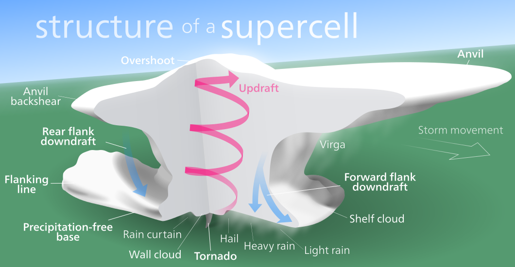
Perfect illustration of a Supercell’s life cycle from Leoti, Kansas via Brad Hannon
[/fusion_text][/fusion_builder_column][fusion_builder_column type=”1_1″ layout=”1_1″ background_position=”left top” background_color=”” border_color=”” border_style=”solid” spacing=”yes” background_image=”” background_repeat=”no-repeat” padding_top=”” padding_right=”” padding_bottom=”” padding_left=”” margin_top=”0px” margin_bottom=”0px” class=”” id=”” animation_type=”” animation_speed=”0.3″ animation_direction=”left” hide_on_mobile=”no” center_content=”no” min_height=”none” last=”true” hover_type=”none” link=”” border_position=”all” align_self=”flex-start” border_sizes_top=”” border_sizes_bottom=”” border_sizes_left=”” border_sizes_right=”” first=”true”][fusion_text]
Supercell Threats:
-
Heavy rain leading to flash flooding
-
Large to very large hail (hailstones likely bigger than golf balls, typically up to tennis ball size and in the stronger Supercell’s they can be anywhere from cricket ball size to oranges, grapefruits and the biggest in the world… bowling ball size)
-
Damaging to destructive straight line winds. These winds are typically above 90-125km/h however wind gusts of more than 200km/h have been recorded around the world
-
Dangerous and very frequent lightning.
-
Tornadoes, and even strong tornadoes which have the ability to destroy well established infrastructure.
[/fusion_text][fusion_text]
Supercell’s arent foreign to Australia. They’ve been around for many years and will continue to appear every storm season. The highest chance of them occurring is through Spring and Summer, however they have been known to occur in any month given the right conditions. In November 2014, Brisbane was struck by a dangerous Supercell which dropped 9cm hail and produced winds to 150km/h leading to hundreds of millions of dollars in damages. Back in 1999, Sydney was struck by a violent Supercell which caused more than $2B worth of damage and dropped more than 500,000 tonnes of hail.
[/fusion_text][/fusion_builder_column][fusion_builder_column type=”1_1″ layout=”1_1″ last=”true” spacing=”yes” center_content=”no” hide_on_mobile=”no” background_color=”” background_image=”” background_repeat=”no-repeat” background_position=”left top” hover_type=”none” link=”” border_position=”all” border_color=”” border_style=”” padding_top=”” padding_right=”” padding_bottom=”” padding_left=”” margin_top=”” margin_bottom=”” animation_type=”” animation_direction=”” animation_speed=”0.1″ animation_offset=”” class=”” id=”” min_height=”” border_sizes_top=”0px” border_sizes_bottom=”0px” border_sizes_left=”0px” border_sizes_right=”0px” first=”true”][fusion_text columns=”” column_min_width=”” column_spacing=”” rule_style=”default” rule_size=”” rule_color=”” content_alignment_medium=”” content_alignment_small=”” content_alignment=”” hide_on_mobile=”small-visibility,medium-visibility,large-visibility” sticky_display=”normal,sticky” class=”” id=”” font_size=”” fusion_font_family_text_font=”Default” fusion_font_variant_text_font=”” line_height=”” letter_spacing=”” text_color=”” animation_type=”” animation_direction=”left” animation_speed=”0.3″ animation_offset=””]
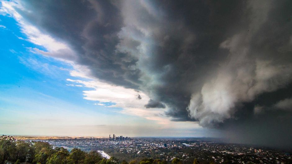
Brisbane, November 2014 Supercell via Kai Linkerhof
[/fusion_text][/fusion_builder_column][/fusion_builder_row][/fusion_builder_container]
Sorry, the comment form is closed at this time.