09 Aug Know Your District – New South Wales & ACT
When it comes to severe weather, regardless of the type of the scenario, one of the age old questions we receive on Higgins Storm Chasing, as well as any other weather page across the globe is ‘Will this affect me at x”. Generally ‘districts’ or much broader areas are labelled rather than specific towns. This is largely due to weather being unpredictable down to the nearest town and weather systems being quite large which means their potential is spread over hundreds of kilometres. Its also due to there sometimes being so many town, that the list would be far too long for it to be beneficial. Some setups or systems are easier to predict than others, but even in those situations, districts or parts of district (i.e Coastal parts of the Northern Rivers and South East QLD Coast) are labelled.
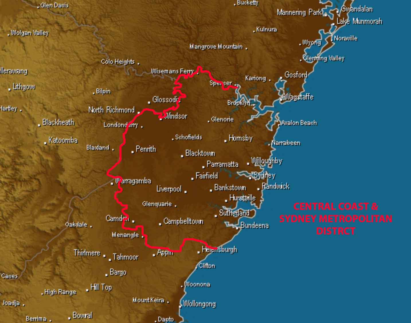
Outline of the Sydney Metropolitan district with many town names included. Base image via Weatherzone
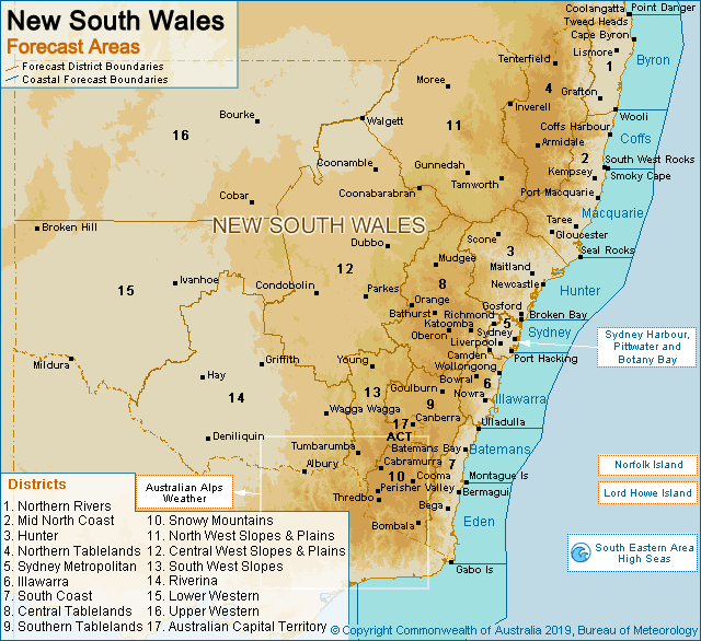
NEW SOUTH WALES and the AUSTRALIAN CAPITAL TERRITORY includes 17 districts according to the Bureau of Meteorology. These districts along with SOME of their respective towns include (Obviously not all towns are named, but if you recognise a nearby town, then chances are you are included in that district):
1 – Northern Rivers: Lismore, Casino, Yamba, Evans Head, Grafton, Brooms Head, Maclean, Kyogle, Murwillumbah, Tweed Heads, Ocean Shores, Rappville, Coraki, Nymboida, Mullumbimby.
2 – Mid North Coast: Coffs Harbour, Port Macquarie, Kempsey, South West Rocks, Taree, Gloucester, Wauchope, Nambucca Heads, Sawmill, Macksville.
3 – Hunter: Newcastle, Singleton, Denman, Merriwa, Scone, Murrurundi, Cessnock, Gosford, Barrington Tops, Muswellbrook, Maitland.
4 – Northern Tablelands: Armidale, Inverell, Tenterfield, Guyra, Glen Innes, Ben Lomond, Walcha, Emmaville, Uralla, Ebor, Tingha, Woodenbong.
5 – Central Coast & Sydney Metropolitan: Sydney City, Penrith, Manly, Sutherland, Hornsby, Mona Vale, Campbelltown, Richmond, Parramatta, Blackown, Camden, Rockdale, Mulgoa, Cowan, Randwick, Epping, Quakers Hill, Terrey Hills, Bondi, Liverpool, Holsworthy.
6 – Illawarra: Wollongong, Helensburgh, Bowral, Moss Vale, Nowra St Georges Basin, Tahmoor, Appin, Albion Park, Kiama, Port Kembla.
7 – South Coast: Ulladulla, Montague Island, Bega, Gabo Island, Batemans Bay, Moruya, Bemboka, Towamba, Merimbula, Eden, Tuross Head
8 – Central Tablelands: Bathurst, Orange, Oberon, Lithgow, Crookwell, Mudgee, Cowra, Blayney, Shooters Hill, Katoomba, Fullerton, Portland, Blackheath, Blaxland, Kandos, Gulgong.
9 – Southern Tablelands: Goulburn, Yass, Bungendore, Braidwood, Captains Flat, Gunning, Nerriga, Murrumbateman, Krawarree, Kain, Wee Jasper, Taralga, Queanbeyan.
10 – Snowy Mountains: Cooma, Jindabyne, Bungarby, Nimmitabel, Bombala, Thredbo Village, Perisher, Perisher Valley, Charlotte Pass, Cabramurra, Adaminaby, Rhine Hills, Mt Kosciuszko
11 – North West Slopes & Plains: Moree, Walgett, Gunnedah, Tamworth, Wee Waa, Gurley, Bullarah, Baradine, Quirindi, Weeis Creek, Barraba, Bingara, Warialda, North Star, Wallangra, Ashford, Bonshaw, Nundle, Burren Junction, Rowena, Mungindi, Come By Chance, Boomi, Collarenebri.
12 – Central West Slopes & Plains: Coonamble, Trangie, Dubbo, Peak Hill, Forbes, West Wyalong, Lake Cargelligo, Condoblin, Tottenham, Narromine, Girilambone, Coonabarabran, Mendooran, Dundeoo, Wellington, Parkes, Temora, Grenfell, Warren, Gilgandra, Quambone.
13 – South West Slopes & Plains: Young, Gundagai, Tumbarumba, Boorowa, Tumult, Cootamundra,
14 – Riverina: Wagga Wagga, Griffith, Hay, Albury, Deniliquin, Narrandera, Junee, Culcaim, Finley, Maude, Conargo, Holbrook, Hillston, Merriwagga, Warbum, Darlington Point, Gunbar, Lockhart, Jerilderie, Coolamon, Barellan, Rankin Springs.
15 – Lower Western: Broken Hill, Pooncarie, Menindee, Ivanhoe, Scotia, Balranald, Mildura East, Darrick, Oxley, Nymagee, Mulurulu, Lake Victoria.
16 – Upper Western: Bourke, Tibooburra, Cobar, White Cliffs, Wilcannia, Lightning Ridge, Hungerford, Brewarrina, Tilpa, Fowlers Gap, Milparinka, Smithville, Borrona Downs.
17 -Australian Capital Territory (ACT): Canberra, Brindabella Ranges, Mt Ginini, Kambah, Gordon, Hall, Naas, Tuggeranong, Tharwa, Tidbinbilla, Holt.
Often, districts can be grouped into larger categories. For example, “Inland” is classed by areas West of the Great Dividing Range, while “Coastal” districts are those that are East of the Great Dividing Range. Northern Inland NSW consists of the NW Slopes & Plains, parts of the Upper Western & Central West Slopes & Plains. Central Inland consists of the Central Tablenads, Central West Slopes & Plains and immediate surrounding areas. South East NSW includes the South Coast, Southern Tablelands, ACT, Snowy Mountains. North East NSW includes the Northern Rivers, Mid North Coast & Northern Tablelands… and yes, Canberra / the ACT is INCLUDED in South East NSW, Eastern, Southern NSW forecasts. The weather doesn’t magically stop at the ACT border, so even if the “ACT” isn’t specifically mentioned, it is included as if it were a district of South Eastern NSW.
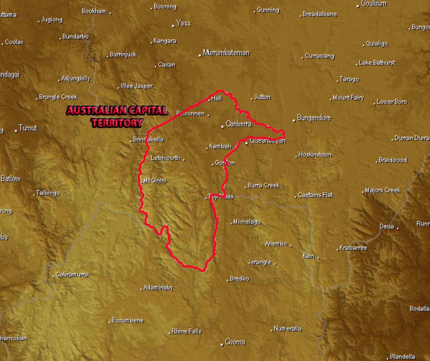
Outline of the Australian Capital Territory with many town names included. Base image via Weatherzone
Sorry, the comment form is closed at this time.