21 Jul Know Your District – South Australia
When it comes to severe weather, regardless of the type of the scenario, one of the age old questions we receive on Higgins Storm Chasing, as well as any other weather page across the globe is ‘Will this affect me at x”. Generally ‘districts’ or much broader areas are labelled rather than specific towns. This is largely due to weather being unpredictable down to the nearest town and weather systems being quite large which means their potential is spread over hundreds of kilometres. Its also due to there sometimes being so many town, that the list would be far too long for it to be beneficial. Some setups or systems are easier to predict than others, but even in those situations, districts or parts of a district (i.e Northern SA, South Eastern SA, Western SA) are labelled.
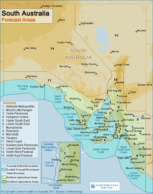
South Australia has 15 forecast districts according to the Bureau of Meteorology. These districts along with SOME of their respective towns include (Obviously not all towns are named, but if you recognise a nearby town, then chances are you are included in that district):
1 – Adelaide Metropolitan: Adelaide, Elizabeth, Glenelg, Noarlunga, Mount Barker, Edinburgh, Mount Crawford, Salisbury, Grange, North Have, Buckland Park, Tea Tree Gully.
2 – Mount Lofty Ranges: Parawa, Stirling, Strathalbyn, Nuriootpa, Victor Harbor, Mount Lofty, Sellicks Beach, Williamstown, Gawler, Coromandel Valley, Bridgewater, Mount Compass, Harrogate, Palmer, Mount Pleasant, Eden Valley, Gawler.
3 – Yorke Peninsula: Kadina, Minlaton, Stenhouse Bay, Edithburgh, Maitland, Cape Willoughby, Warooka, Bute, Bluff Beach, Ardrossan, Kulpara, Port Broughton.
4 – Kangaroo Island: Kingscote, Parndana, Cuttlefish Bay, Seal Bay, Gosse, Cassini, North Cape, Stokes Bay, Cape Borda, Flinders Chase, Karatta.
5 – Upper South East: Keith, Bordertown, Meningie, Salt Creek, Willalooka, Coonalpyn.
6 – Lower South East: Robe, Coonawarra, Naracoorte, Mount Gambier, Padthaway, Cape Jaffa, Penola, Lucinda, Beachport.
7 – Murraylands: Lameroo, Karoonda, Murray Bridge, Varuna, Coomandook, Milang, Asheville, Mannum, Swan Reach, Alawoona.
8 – Riverland: Renmark, Morgan, Waikerie, Blanchetown, Wunkar, Loxton, Berri,
9 – Mid North: Roseworthy, Clare, Jamestown, Port Pirie, Snowtown, Roverstown, Eudunda, Kaunda, Balaclava, Spalding, Crystal Brook, Mallala, Angle Vale.
10 – Flinders: Hawker, Port Augusta, Melrose, Peterborough, Orroroo, Carrieton, Blinman.
11 – West Coast: Ceduna, Nullarbor, Cook, Streaky Bay, Wudinna, Yalata, Lock, Port Kenny, Elliston, Minima.
12 – Eastern Eyre Peninsula: Kimba, Cleve, Whyalla, Contra, Iron Baron, Cowell, Arno Bay, Rudall,
13 – Lower Eyre Peninsula: Cummins, Coffin Bay, Port Lincoln, Butler, Port Neill, Tumby Bay, Karkoo.
14 – North West Pastoral: Woomera, Roxby Downs, Tarcoola, Coober Pedy, Ernabella, Marla, Oak Valley, Iron Knob, Nonning,
15 – North East Pastoral: Moomba, Marree, Oodnadatta, Leigh Creek, Yunta, Innamincka, Mingary, Manna Hill, Beltana, Farina, Merty Merty.
Often districts are grouped into larger categories. Some examples of this happening in South Australian areas – ‘Northern’ which consists of both Pastoral districts as well as ares North of Port Augusta. ‘Western’ which includes the West Coast, North West Pastoral and Western parts of the Eyre Peninsula. South Eastern, which includes the Lower & Upper South East, Murraylands and any further areas East and South of the Mt Lofty Ranges. Due to the vastness of rural South Australia, these groupings are used far more often than in some other States, as there are large areas between some towns so its far easier to group them.
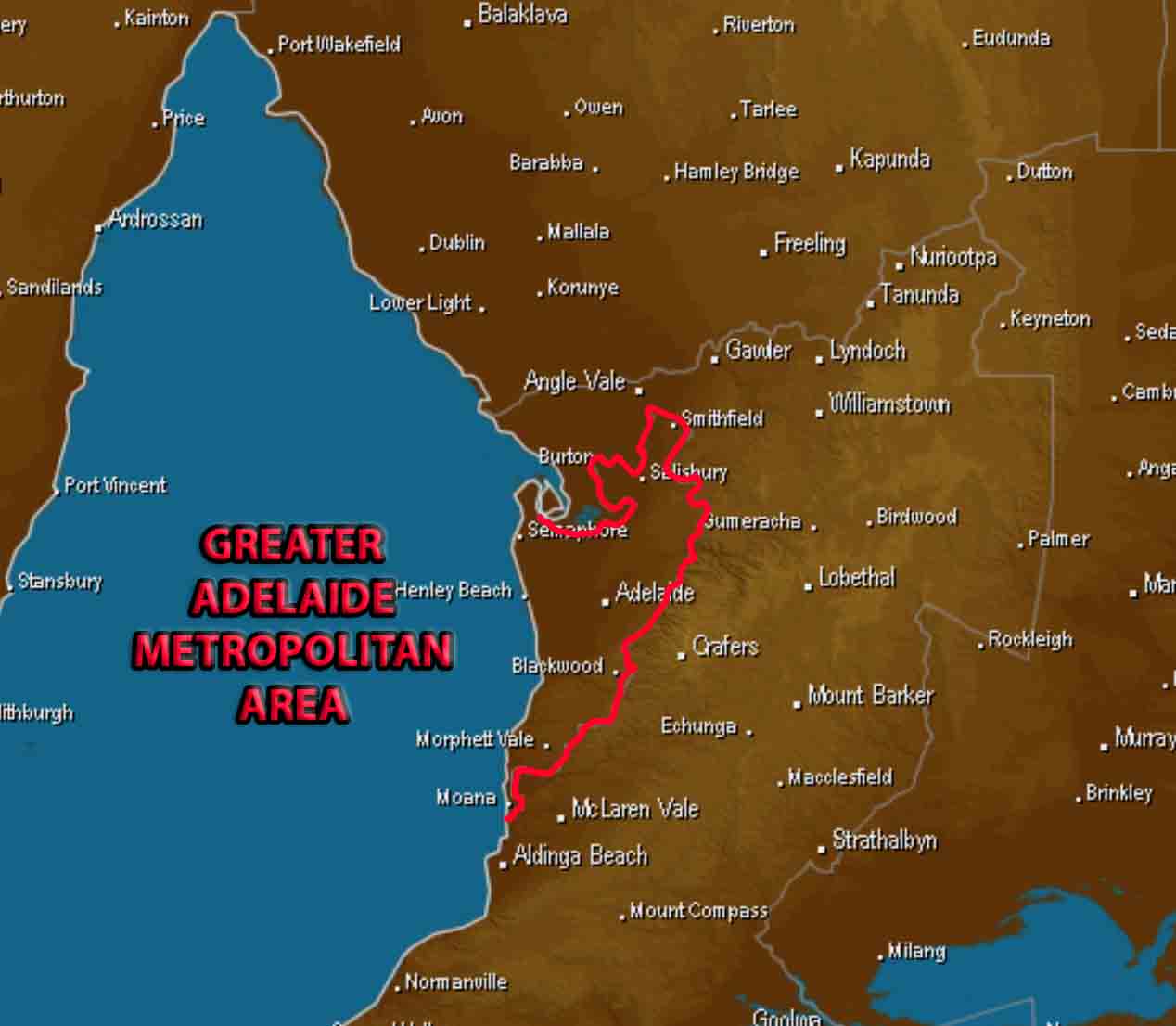
Outline of the Adelaide Metropolitan district with many town names included. Base image via Weatherzone
Sorry, the comment form is closed at this time.