08 Aug Know Your District – Victoria
When it comes to severe weather, regardless of the type of the scenario, one of the age old questions we receive on Higgins Storm Chasing, as well as any other weather page across the globe is ‘Will this affect me at x”. Generally ‘districts’ or much broader areas are labelled rather than specific towns. This is largely due to weather being unpredictable down to the nearest town and weather systems being quite large which means their potential is spread over hundreds of kilometres. Its also due to there sometimes being so many town, that the list would be far too long for it to be beneficial. Some setups or systems are easier to predict than others, but even in those situations, districts or parts of a district (i.e Coastal parts of VIC or areas West of the Ranges) are labelled.
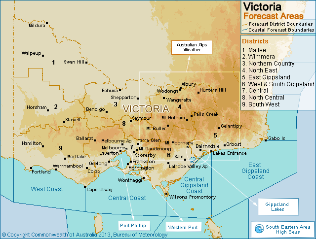
Victoria has 9 forecast districts according to the Bureau of Meteorology. These districts along with SOME of their respective towns include (Obviously not all towns are named, but if you recognise a nearby town, then chances are you are included in that district):
1 – Mallee: Mildura, Swan Hill, Ouyen, Hopetoun, Donald, Charlton, Berriwillock, Cowangie, Kerang, Manangatang, Robinvale, Tooleybuc, Cohuna, Red Cliffs, Liparoo, Walpeup
2 – Wimmera: Horsham, Nhill, Edenhope, St Arnaud, Stawell, Warracknabeal, Rainbow, Yanac, Mockinya, Paradise, Kellalac, The Grampians, Longerenong, Pyrenees, Ben Nevis, Kanagulk, Halls Gap.
3 – Northern Country: Bendigo, Echuca, Shepparton, Rochester, Kyabram, Cobram, Euroa, Heathcote, Wedderbum, Pyramid Hill, Barraport, Femihurst, Inglewood, Tatura, Yarrawonga, Mulwala.
4 – North East: Mount Buller, Mount Hotham, Falls Creek, Darmouth, Dinner Plain, Mansfield, Benalla, Beechworth, Corowa, Wangaratta, Wodonga, Corryong, Rutherglen, Myrtelford.
5 – East Gippsland: Bairnsdale, Lakes Entrance, Mallacoota, Orbost, Point Hicks, Mount Nowa Nowa, Gelantipy, Combienbar, Paynesville, Glenaladale, Bullumwaal, Omeo, Cabbage Tree Creek, Bemm River, Cann River.
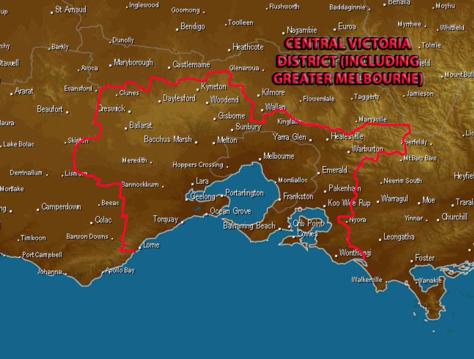
Central Victoria highlighted, including Greater Melbourne. Base image via Weatherzone
6 – West & South Gippsland: Latrobe Valley, Sale, Rawson, Moe, Churchill, Traralgon, Yarram, Leongatha, Foster, Yanakie, Seaspray, Loch Sport, Mt Moornapa.
7 – Central (includes Melbourne Metropolitan): Melbourne City, Essendon, Geelong, Ballarat, Kyneton, Meredith, Torquay, Lorne, Ocean Grove, Frankston, Sunbury, Doreen, Healesville, Brighton, Port Phillip Bay, Lara, Creswick, Daylesford, Bacchus Marsh, Melton, Glen Waverley, Lancefield, Craigieburn, Wonga Park, Coldstream, Beaconsfield, Emerald, Pakenham, Koo Wee Rup, Coronet Bay, Cape Paterson, Wonthaggi, Hastings, Mornington, Sorrento.
8 – North Central: Maryborough, Castlemaine, Dunolly, Yea, Kilmore, Alexandra, Seymour, Wallan, Marysville, Flowerdale, Bradford, Eildon, Buxton.
9 – South West: Warrnambool, Colac, Hamilton, Dartmoor, Portland, Port Fairy, Mortlake, Casterton, Cape Otway, Ararat, Beaufort, Skipton, Lismore, Camperdown, Dundonnell, Terang, Avoca.
Often districts are grouped into larger categories. Some examples of this happening in Victoria area – ‘Inland’ which consists of all areas North of Greater Melbourne and West of the Victoria Alpine region. ‘Western’ which consists of areas West of Greater Melbourne and Yarrawonga. ‘Eastern’ which consists of the Gippsland and North East (Victorian Alps) of the State. Coastal which consists of the Gippsland, South West and Greater Melbourne districts.
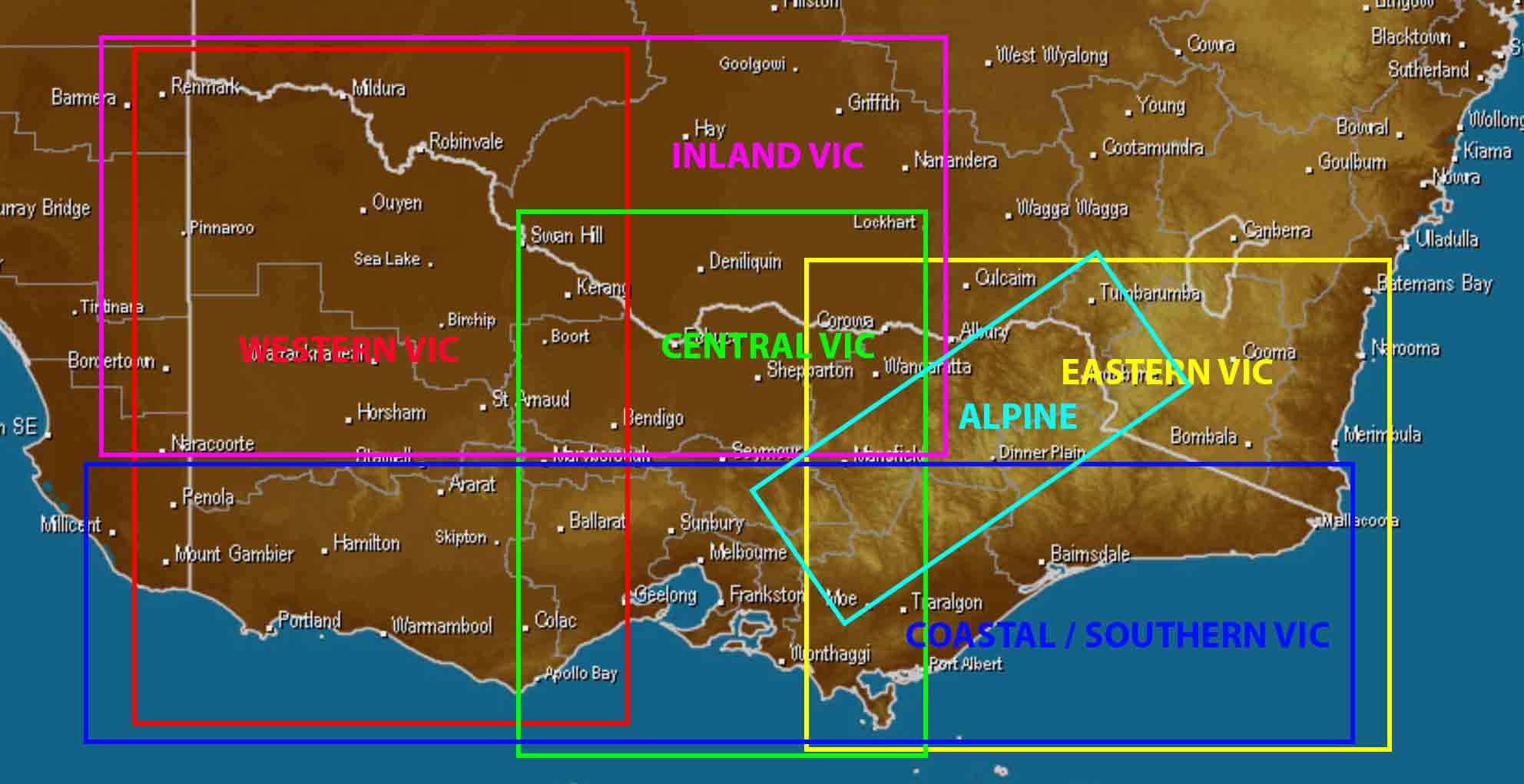
Broader ‘combined’ districts across VIC – coloured text matches colour coded boxes. Note: Boxes are overlapping into SA & NSW (those States aren’t included in this). Base image via Weatherzone
Sorry, the comment form is closed at this time.