22 Jul Know Your District – Western Australia
When it comes to severe weather, regardless of the type of the scenario, one of the age old questions we receive on Higgins Storm Chasing, as well as any other weather page across the globe is ‘Will this affect me at x”. Generally ‘districts’ or much broader areas are labelled rather than specific towns. This is largely due to weather being unpredictable down to the nearest town and weather systems being quite large which means their potential is spread over hundreds of kilometres. Its also due to there sometimes being so many town, that the list would be far too long for it to be beneficial. Some setups or systems are easier to predict than others, but even in those situations, districts or parts of a district (i.e Northern WA, South West WA or Inland WA) are labelled. Above image is a base image from Weatherzone.
Western Australia 2 divisions which are divided evenly into 7 forecast districts each according to the Bureau of Meteorology. These districts along with SOME of their respective towns include (Obviously not all towns are named, but if you recognise a nearby town, then chances are you are included in that district):
Mining & Pastoral:
1 – Kimberley: Broome, Fitzroy Crossing, Halls Creek, Wyndham, Troughton Island, Kalumburu, Kununurra, Wallal Downs, Lombadina, Derby, Bidyadanga, Mandora, Dampier Peninsula, Dampier, Media, Kuri Bay, Mitchell Plateau, Doongan, Mt Elizabeth, Lake Argyle, Warmup, Durack.
2 – Pilbara: Port Hedland, Exmouth, Onslow, Karratha, Roebourne, West Roebourne, Newman, Tom Price, Paraburdoo, Marble Bar, Telfer, Roy Hill, Pannawonica, Wigttenoom, Indee, Goldsworthy, Pardoo, Shay Gap, Dampier, Barrow Island, Nyang, Cane, Learmonth, Karijini, Mardie.
3 – Gascoyne: Carnarvon, Denham, Shark Bay, Meekatharra, Gascoyne Junction, Useless Loop, Murchison, Yalgoo, Cue, Mount Magnet, Sandstone, Cue, Peak Hill, Paynes Find, Evanston.
4 – Goldfields: Kalgoorlie, Leinster, Leonora, Boulder, Norseman, Laverton, Coolgardie, Bandya, Sir Samuel, Lawlers, Kookynie, Higginsville, Wiluna.
5 – Eucla: Eucla, Forrest, Eyre, Balgair, Haig, Caiguna,
6 – Northern Interior: Balgo Hills, Bamboo Creek.
7 – Southern Interior: Giles, Warburton, Wingellina, Carnegie.
South West Land Division:
8 – Central West: Geraldton, Dongala, Kalbarri, Morawa, Bunjil, Coorow, Jurien Bay, Leeman, Moora, Calingiri, Bolgart, New Norcia, Dandaragan, Canna, Binnu, Northampton, North Island.
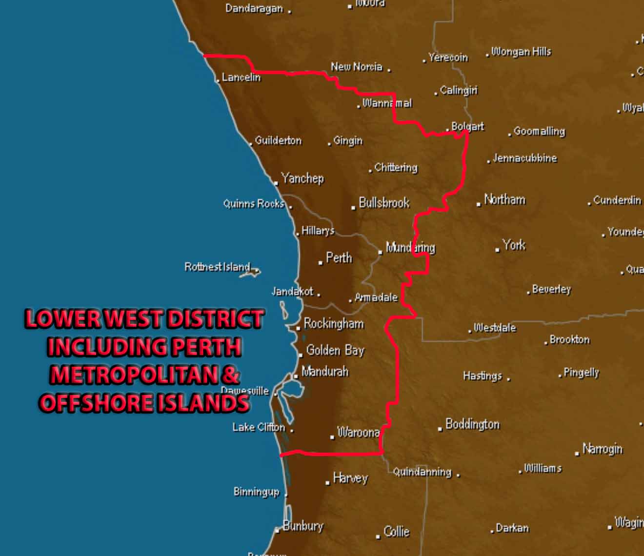
9 – Lower West: Perth, Gingin, Maundering, Bullsbrook, Mandurah, Herron, Waroona, Rockingam, Rottnest Island, Hillarys, Lancelin, Jandakot, golden Bay, Coolup, Serpentine, Byford, Gosnells, Garden Island, Halls Head, Preston Beach, Scarborough, Two Rocks, Dwellingup.
10 – South West: Cape Naturaliste, Cape Leeuwin, Windy Harbour, Northcliffe, Manjimup, Bridgetown, Mullalyup, Donnybrook, Collie, Harvey, Busselton, Walpole.
11 – South Coastal: Denmark, Borden, Gnowangerup, Napier, Albany, Manypeaks, Bremer Bay, Jacup, Jerramungup, Mount Barker, Wellstead.
12 – South East Coastal: Esperance, Hopetoun, Ravensthorpe, Grass Patch, Scaddan, Condingup, Salmon Gums, Beaumont.
13 – Great Southern: Lake Grace, Katanning, Narrogin, Cranbrook, Kojonup, Wagin, Boddington, Hastings, Brockton, Corrigin, Hyden, Newdegate, Dumbleyung, Train Rock, Harrismith, Mount Madden, Williams.
14 – Central Wheat Belt: Merredin, York, Northam, Goomalling, Beacon, Southern Cross, Dalwallinu, Goodlands, Yorkakine, West Golleton, Bruce Rock, Babkin, Quairading, Beverley, Wubin, Koolyanobbing.
Western Australia is arguably the most diverse State for weather, so sometimes its important to to group large areas, particularly in the South or in the Far North for widespread severe weather. Cold fronts in Winter can impact Southern and South West WA which may include any of the following: South West, Lower West, Southern Coastal, Great Southern, Central Wheat Belt. Storms can often impact the Goldfields, Great Southern, Central Wheat Belt, South Coastal areas and this is often referred to as the Central & Southern Interior districts. Cyclones can impact the Northern districts and so the Pilbara and Kimberley will sometimes be referred to in general as “Northern WA”. Western Central WA is the Southern reaches of the Pilbara, Gascoyne and Northern parts of the Central West.

BOM Forecast Districts for WA with the Mining & Pastoral + South West Land Division sectors identified.
Sorry, the comment form is closed at this time.