21 Jul Know Your District – Northern Territory
When it comes to severe weather, regardless of the type of the scenario, one of the age old questions we receive on Higgins Storm Chasing, as well as any other weather page across the globe is ‘Will this affect me at x”. Generally ‘districts’ or much broader areas are labelled rather than specific towns. This is largely due to weather being unpredictable down to the nearest town and weather systems being quite large which means their potential is spread over hundreds of kilometres. Its also due to there sometimes being so many town, that the list would be far too long for it to be beneficial. Some setups or systems are easier to predict than others, but even in those situations, districts or parts of a district (i.e Southern NT, Northern NT, North West or North East NT) are labelled.
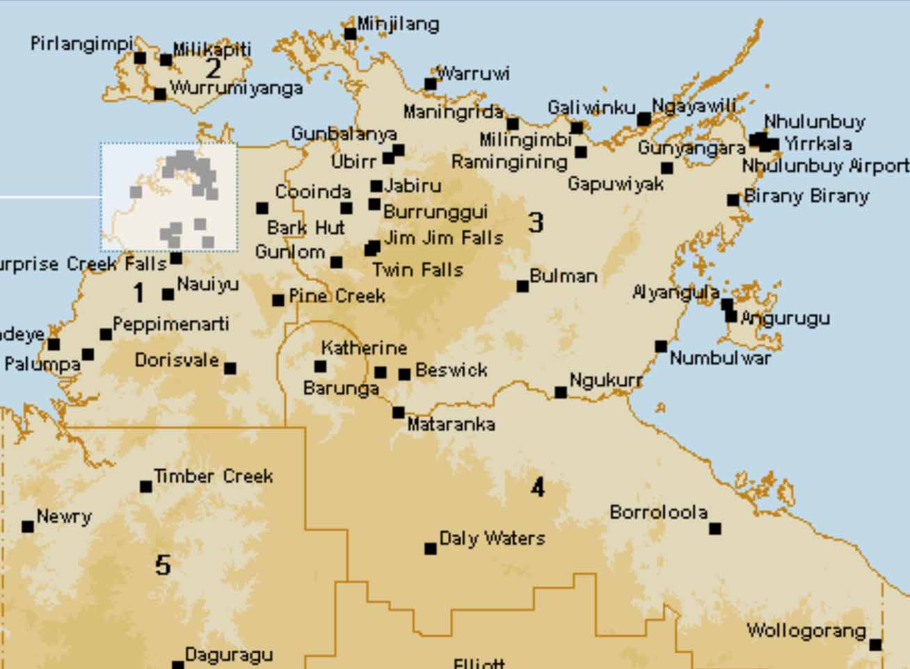
The Northern Territory has 9 forecast districts according to the Bureau of Meteorology. These districts along with SOME of their respective towns include (Obviously not all towns are named, but if you recognise a nearby town, then chances are you are included in that district):
1 – Darwin-Daly: Darwin, Berrimah, Wagait Beach, Batchelor, Wangi Falls, Adelaide River, Wadeye, Plump, Dorisvale, Cooinda, Pine Creek, Berry Springs, Florence Falls, Tjaynera Falls, Noonamah, Humpty Doo, Howard Springs, Leanyer, Nightlife, Coolalinga.
2 – Tiwi: Pirlangimpi, Wurrumiyanga, Milikapiti, Nguiu, Bathurst Island,
3 – Arnhem: Nhulunbuy, Busman, Twin Falls, Minjilang, Galiwinku, Warruwi, Maningrida, Ngukurr, Jim Jim Falls, Jabiru, Ubirr, Gunlom, Milingimbi, Groote Eylandt, North East Island, Alyangula, Numbulwar, Cape Shield, Cape Wilberforce, Cape Wessel, Gove, Ramingining.
4 – Carpentaria: Katherine, Borroloola, Wollogorang, Daly Waters, Mataranka, Centre Island, McArthur River, Larrimah.
5 – Gregory: Victoria River Downs, Timber Creek, Kidman Springs, Lajamanu, Wave Hill, Newry, Daguragu.
6 – Barkly: Tennant Creek, Elliott, Cresswell Downs, Barrow Creek, Ali Curung, Alpurrurulam, Ampilatwatja, Burnett Downs.
7 – Simpson: Alice Springs, Jervois, Ti Tree, Kulgera, Titjikala, Santa Teresa, Ross River, Arltunga, Engawala, Territory Grape Farm, Finke.
8 – Lasseter: Uluru / Yulara, Docker River, Curtin Springs, Watarrka, Hermannsburg, Papaya, Xulungurru, Mereenie, Areyonga, Kintore, Haasts Bluff.
9 – Tanami: Rabbit Flat, Yuendumu.
There are a lot of conflicting boundaries for the Northern Territory, the above list seems to fit the most common and more importantly it follows the Bureau of Meteorology in which we are talking specifically about forecast districts. There is an exceptional amount of space between some towns in districts – for example, there are really only 2 towns in the Tanami district which covers 30%+ of Western NT area. This is why the NT is one of the more favourable regions to group. The Northern NT consists of the Darwin-Daly, Tiwi and Arnhem districts as well as any further districts North of and including the town of Katherine in the Carpentaria district. The North East consists of anywhere that borders the Gulf of Carpentaria Coastline while Southern NT areas include anywhere South of Tennant Creek which favours mostly the Simpson, Lasseter and Tanami districts.

The Northern Territory Districts according to BOM in relation to district forecasting.
Sorry, the comment form is closed at this time.