16 Oct Wall Clouds
[fusion_builder_container hundred_percent=”no” equal_height_columns=”no” menu_anchor=”” hide_on_mobile=”small-visibility,medium-visibility,large-visibility” class=”” id=”” background_color=”” background_image=”” background_position=”center center” background_repeat=”no-repeat” fade=”no” background_parallax=”none” enable_mobile=”no” parallax_speed=”0.3″ video_mp4=”” video_webm=”” video_ogv=”” video_url=”” video_aspect_ratio=”16:9″ video_loop=”yes” video_mute=”yes” overlay_color=”” video_preview_image=”” border_color=”” border_style=”solid” margin_top=”” margin_bottom=”” padding_top=”20px” padding_right=”” padding_bottom=”20px” padding_left=”” type=”legacy”][fusion_builder_row][fusion_builder_column type=”1_1″ layout=”1_1″ spacing=”” center_content=”no” hover_type=”none” link=”” min_height=”” hide_on_mobile=”small-visibility,medium-visibility,large-visibility” class=”” id=”” background_color=”” background_image=”” background_position=”left top” background_repeat=”no-repeat” border_color=”” border_style=”solid” border_position=”all” padding_top=”” padding_right=”” padding_bottom=”” padding_left=”” margin_top=”” margin_bottom=”” animation_type=”” animation_direction=”left” animation_speed=”0.3″ animation_offset=”” last=”true” border_sizes_top=”0″ border_sizes_bottom=”0″ border_sizes_left=”0″ border_sizes_right=”0″ first=”true”][fusion_text]
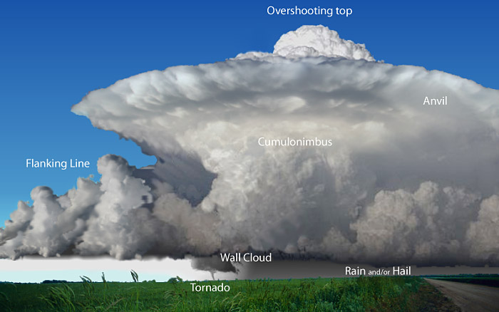
Wall clouds are some of the most eye capturing parts of storm chasing, and are often the visual appearance that a thunderstorm (or likely Supercell if a wall cloud is present) is taking the next step to becoming even more dangerous. The wall cloud typically indicates where the area of strongest updraft is occurring and rarely producing any precipitation itself, but rotating wall clouds can be a clear cut indication of a rotating mesocyclone within the thunderstorm which can produce tornadoes, some of which may become strong and deadly.
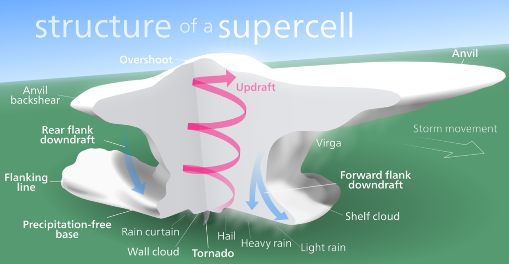
Mechanics of a Supercell showing where a wall cloud is located
Wall clouds are formed through a process called entrainment. This is when warm, moist inflow air, rises and converges. It overpowers the rain-cooled air which is normally associated with the downdraft of a thunderstorm. As the warm air entrains the cooler air, the temperature and dew points increase. As the air continues to rise, it becomes statured which then leads to a process of further cloud development occurring and sometimes this process leads to the wall cloud developing. The wall cloud will also develop at the base of a thunderstorm and may also develop through the formation of rising scud. Wall clouds never produce precipitation as they are in an area called a ‘rain-free base’. The wall cloud is a clear cut indicator that a thunderstorm has entered supercell mode as its the clear cut line between the updraft and downdraft. The separation of these 2 drafts is vital for supercell production as this separation causes the mesocyclone to develop and work in perfect harmony. As long as this process takes place, a thunderstorm will remain a supercell.. as soon as the downdraft and updraft become mixed, then the storm begins to weaken.
Their structure is unique as they can be anything from minuscule in size (in the big picture) to absolutely mammoth (between 1km and 8km+). As stated above, they form in the warmer inflow region of the storm which is coinciding with the direction of the steering winds. In the Northern hemisphere, wall clouds typically form on the Southern / South-West regions of a supercell, however they normally form over the Northern or North-East regions of a supercell in the Southern hemisphere.
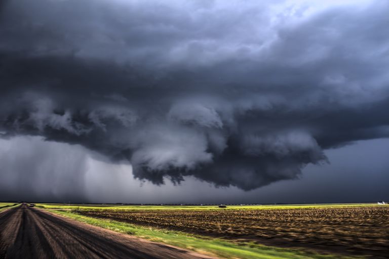
Wall cloud captured by NZP Chasers
Attached to many wall clouds can be what is known as a tail cloud, which is a ragged band of cloud extending from the wall cloud to the precipitation core. Another accessory is the flumen cloud which is commonly known as a beavers tail. This is formed by warm, humid inflow in a strong thunderstorm but can often be mistaken for a tornado. Despite the presence of a beavers tail normally being associated with tornadic risk, the cloud itself does not rotate.
Tornadogenesis is most likely to occur when the wall cloud has a persistent and rapid rotation present. The wall cloud itself however typically precedes tornadogensis by roughly between 10-20 minutes, but depending on the atmospheric conditions present on the day, it can be as little as a few minutes or as much as an hour or more. Although rotating, strong, ominous wall clouds typically contain tornadoes (and strong tornadoes for that matter), its not the rotating wall cloud itself that produces the tornado. That process is left to the rear flank downdraft (RFD) which initiates the tornado production. In some cases, when tornado families are born (a supercell which produces several individual tornadoes), the wall cloud will often die and become reinvigorated, long enough so it can spawn another tornado and often if this process is occurring, it will occur while the current tornado is still active. This is known as cyclic tornadogenesis.

Image of a huge rotating wall cloud over Wyoming. Image credit: Colt Forney
[/fusion_text][/fusion_builder_column][/fusion_builder_row][/fusion_builder_container]
Sorry, the comment form is closed at this time.