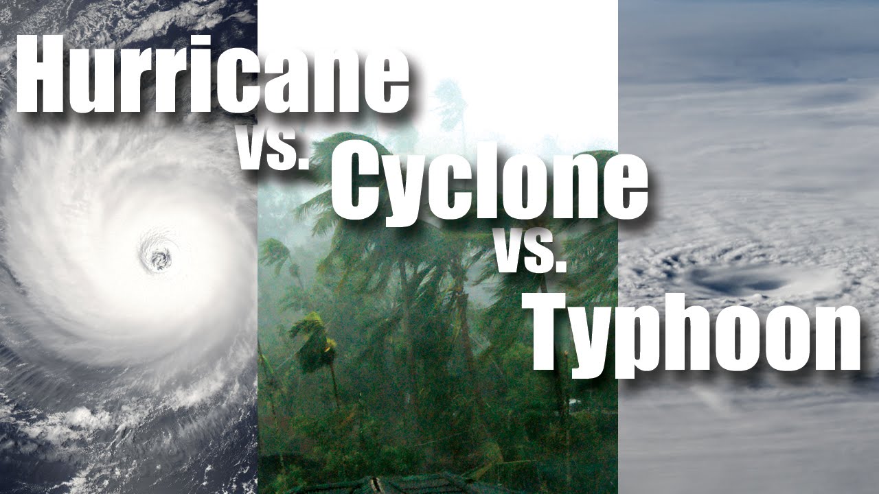
16 Oct Cyclones, Typhoons & Hurricanes
[fusion_builder_container hundred_percent=”no” equal_height_columns=”no” menu_anchor=”” hide_on_mobile=”small-visibility,medium-visibility,large-visibility” class=”” id=”” background_color=”” background_image=”” background_position=”center center” background_repeat=”no-repeat” fade=”no” background_parallax=”none” enable_mobile=”no” parallax_speed=”0.3″ video_mp4=”” video_webm=”” video_ogv=”” video_url=”” video_aspect_ratio=”16:9″ video_loop=”yes” video_mute=”yes” overlay_color=”” video_preview_image=”” border_color=”” border_style=”solid” margin_top=”” margin_bottom=”” padding_top=”20px” padding_right=”” padding_bottom=”20px” padding_left=”” type=”legacy”][fusion_builder_row][fusion_builder_column type=”1_1″ layout=”1_1″ spacing=”” center_content=”no” hover_type=”none” link=”” min_height=”” hide_on_mobile=”small-visibility,medium-visibility,large-visibility” class=”” id=”” background_color=”” background_image=”” background_position=”left top” background_repeat=”no-repeat” border_color=”” border_style=”solid” border_position=”all” padding_top=”” padding_right=”” padding_bottom=”” padding_left=”” margin_top=”” margin_bottom=”” animation_type=”” animation_direction=”left” animation_speed=”0.3″ animation_offset=”” last=”true” border_sizes_top=”0″ border_sizes_bottom=”0″ border_sizes_left=”0″ border_sizes_right=”0″ first=”true”][fusion_text]
Its a common question, particularly through the peak times of each season as to what is the difference between Cyclones, Hurricanes and Typhoon’s. The simple answer is hole there are some subtle differences, they are basically all the same thing. Cyclones, Hurricanes and Typhoon’s are all very large, rotating areas of low pressure which have a central point (sometimes the eye) and produce extensive severe potential through the form of damaging, destructive or very destructive winds along with heavy to torrential rainfall which likely leads to flash flooding.
So where does each one form?
-
Cyclones are ‘basically’ solely related to the Southern Hemisphere. Areas such as Indian, Bangladesh, Sri Lanka, Africa, Australia, New Zealand, Papua New Guinea, Fiji, Tonga, New Caledonia, Vanuatu all name their low pressure system as ‘cyclones’.
-
Hurricanes are solely related to the Atlantic Ocean and Eastern Pacific (essentially the ‘Americas’). Areas such as the United States of America, Canada, Mexico, The Bahamas, Puerto Rico, U.S & British Virgin Islands, Dominican Republic and associated islands, South America and even on the off chance that the United Kingdom & surrounds received one – then its named a Hurricane.
-
Typhoons are solely related to the Western Pacific and Asian Countries. Places such as Taiwan, Japan, China, the Philippines and surrounding islands.
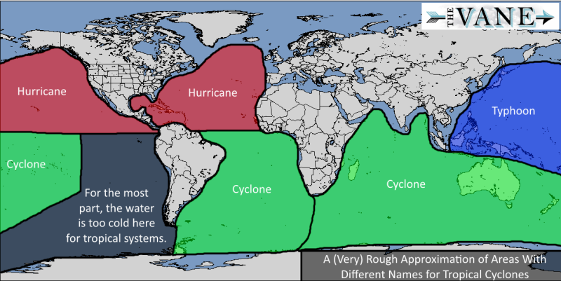
An approximation of where each system occurs in regards to regions and oceans via The Vane
In all cases, if a Cyclone, Typhoon or Hurricane was to move out of tropical waters (waters over 26ºc) and becomes cold cored, then it becomes a sub-tropical system – these are more likely over areas such as New Zealand, the U.K, Canada. They still maintain the same strength, its just by definition their mechanics have now been altered. If anything, this transition usually increases the size and wind spread of the system.
So who names the systems?
When it comes to the Southern Hemisphere then there are quite a few areas.
-
The Australian region is marked by 3 agencies. The Australian Bureau of Meteorology (10-36ºS, 90-160ºE), the Papua New Guinea National Weather Service (Equator to 10ºS, 141-160ºE) and the Badan Meteorologi (Equator to 10ºS, 90-141ºE)
-
The Southern Pacific is monitored by the Fiji Meteorological Service (Equator to 25ºS, 160ºE to 120ºW) and the New Zealand Metserivce (25-40ºS, 160ºE to 120ºW).
-
The South-West Indian Ocean is monitored by Meteo France, Reunion (equator to 40ºS, African Coast to 90ºE).
For the Northern Hemisphere its more clear cut..
-
Northern Indian Ocean: India Meteorological Department (Equator Northwards, 100 to 45ºE)
-
Western Pacific: Japan Meteorological Department (Equator to 60ºN, 180 to 100ºE)
-
Eastern Pacific: United States Central Pacific Hurricane Center (Equator Northwards, 140ºW to 180º)
-
North Atlantic: United States National Hurricane Center, Miami, Florida (Equator Northwards, African Coast to 140ºW).
The Joint Typhoon Warning Centre also specialises in systems outside of the Atlantic.
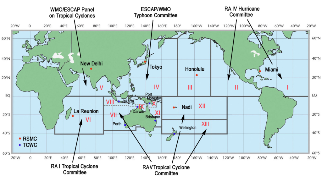
An illustration showing who monitors which area across the globe.
How do they get the names?
Each region has their own names that they use. A list can be found here () for the current and short-term future names. If a named system moves across areas of responsibility (which typically will only happen between Fiji and Australia) then it retains the name that it was born with. Some systems can be given multiple names, but this is purely after the fact. The way this happens is a system will develop, reach cyclone status and be given a name, it will then have to die, lose its circulation and then later on redevelop when the circulation tightens. It will then be given a new name, however later on through the historical perspective it will be named as Cyclone X-Y (hyphenated name). Some systems may also be named something, but referred to as something else – the best example of this is Typhoon Haiyan which was commonly referred to as Yolanda by the Filipinos.
The Australian and Fiji Meteorological agencies continue on through the alphabet each Season (click here for the Australian naming system), while all other agencies start each season again at “A” regardless of where the last season finished. While its a common conspiracy that tropical systems are only named after females, this is false.. names alternate male, female, male, female. The only time a name won’t be used (in regards to Australia) is if that name is of current debate at the time and is subject to ridicule, such as a politicians name. Similar sounding names are also avoided (ie. June & Jane) to avoid confusion – although this rarely will happen due to the alphabet naming policy.
[/fusion_text][/fusion_builder_column][/fusion_builder_row][/fusion_builder_container]
Sorry, the comment form is closed at this time.