16 Oct Tropical Cyclones What are they & how do they form?
[fusion_builder_container hundred_percent=”no” equal_height_columns=”no” menu_anchor=”” hide_on_mobile=”small-visibility,medium-visibility,large-visibility” class=”” id=”” background_color=”” background_image=”” background_position=”center center” background_repeat=”no-repeat” fade=”no” background_parallax=”none” enable_mobile=”no” parallax_speed=”0.3″ video_mp4=”” video_webm=”” video_ogv=”” video_url=”” video_aspect_ratio=”16:9″ video_loop=”yes” video_mute=”yes” overlay_color=”” video_preview_image=”” border_color=”” border_style=”solid” margin_top=”” margin_bottom=”” padding_top=”20px” padding_right=”” padding_bottom=”20px” padding_left=”” type=”legacy”][fusion_builder_row][fusion_builder_column type=”1_1″ layout=”1_1″ spacing=”” center_content=”no” hover_type=”none” link=”” min_height=”” hide_on_mobile=”small-visibility,medium-visibility,large-visibility” class=”” id=”” background_color=”” background_image=”” background_position=”left top” background_repeat=”no-repeat” border_color=”” border_style=”solid” border_position=”all” padding_top=”” padding_right=”” padding_bottom=”” padding_left=”” margin_top=”” margin_bottom=”” animation_type=”” animation_direction=”left” animation_speed=”0.3″ animation_offset=”” last=”true” border_sizes_top=”0″ border_sizes_bottom=”0″ border_sizes_left=”0″ border_sizes_right=”0″ first=”true”][fusion_text]
CYCLONES (TROPICAL): WHAT ARE THEY?
Tropical Cyclones have been arguably the biggest cause of loss of life and financial ruins throughout Australian history when it comes to natural disasters. They are also ironically (due to their known dangers) the lifeblood of Australia’s agricultural wellbeing and are a required weather phenomenon each year in Australia… In this write up, we will answer many questions including what are cyclones, how do they form, their threats and dangers, their positive side and what are some of the most well known / strongest cyclones to impact Australia in history.
What are Tropical Cyclones and how do they form?
Tropical Cyclones are basically large scale low pressure systems. There is more to their mechanics than that though. Tropical Cyclones develop over warm tropical waters (basically through areas North of the Tropic of Capricorn which runs from Rockhampton on the QLD Coast to just North of Minilya or South of Learmonth on the Central-Western Coast of WA). The requirements for tropical cyclone formation are standard across the entire world and they include:
-
Warm ocean temperatures: These waters are required to be at least 26ºc, however if they can be much warmer than that (up to or even exceeding 30ºc), then the depth of the water becomes warmer also, and the deeper that its 26ºc+ then the better the water conditions are for cyclogenesis to occur.
-
Low vertical wind shear: High vertical wind shear can severely hinder the transition of large areas of convection into cyclogenesis formation. The lower the vertical wind shear, the better, as this will allow the low pressure region to develop and mature and thus producing a tropical cyclone.
-
Monsoon Trough: These systems require the assistance of a monsoon trough to be present. The low pressure regions develop along the trough (which by nature is one of lower pressure) which spark areas of convection. As time progresses and with the assistance of the above mentioned requirements, a cyclone can be born.
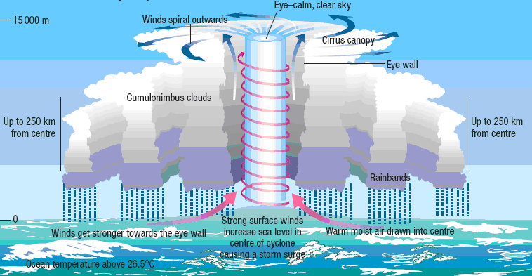
Illustration of how tropical cyclone form
The process behind a tropical cyclone developing is quite fascinating also, but also a little repetitive as each system takes a very similar process. A monsoon trough will develop across tropical parts of Australia, as time goes on, this monsoon trough will spawn several areas of thunderstorm activity, known as monsoon convection or monsoon thunderstorms. These storms due to the way they develop, will last for extreme periods of time, with lightning always being detected within the large mass. As time goes on, a low pressure region will develop within this convection and under the right conditions, it will then strengthen (mostly slowly, but sometimes very rapidly if the conditions are perfect) into a tropical low and tropical cyclone. The cyclone will then seek more favourable environments and take a track either towards or away from mainland Australia.
Tropical Cyclone Categories and their threats?
Tropical cyclones are categorised on by the Australian Scale and are rated between 1 and 5, with Category 1 being the weakest and Category 5 being the strongest. As each category increases, there is an increase in the risks associated with that system… granted all systems are different due to population, the speed of the system, the size of the system etc. A slow moving category 1 or 2 system over populated areas may be more dangerous than an extremely fast moving category 4 or 5 system over forestry.
In Australia, cyclones are rated by wind gusts NOT sustained winds. This is different from the rest of the world which categorises through the 10 minute sustained wind average and America which is the only country to rate by 1 minute sustained wind average.
-
Category 1 – Less than 125km/h (typically above 90km/h though)
-
Category 2 – Between 125 and 164km/h
-
Category 3 (Severe) – Between 165 and 224km/h
-
Category 4 (Severe) – Between 225 and 279km/h
-
Category 5 (Severe) – More than 280km/h
Note: There is no such thing as a Category 6 tropical system anywhere in the world and there never will be.
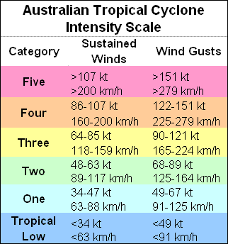
Cyclone Intensity Chart via BOM
The threats extend beyond the winds of cyclones, and often the winds are perceived as the be all and end all of these systems. In fact, the biggest danger is the rainfall. Regardless of the strength of the system, tropical systems / cyclones will ALWAYS produce significant amounts of rain. Some of the heaviest rain producing systems are often some of the weakest – both in Australia and globally. The rainfall that occurs can often lead to not only flash flooding, but significant, major and life threatening river flooding that inundates homes, businesses and sometimes… entire towns!
Tropical cyclones also produce storm surges, the stronger the system and potentially the timing of the tides then the stronger the storm surge. Storm surges can be deadly as the sea surges inland, producing phenomenally high waves and potentially catastrophic flooding along the Coastline. They can be strong enough to sometimes sweep buildings off their foundations, wash cars and people away.

Illustration of what a storm surge is via the Queensland Government
Waterspouts and tornadoes are also an increased threat, especially with stronger systems. The increased rotation associated with the tropical cyclone itself, along with the monsoon trough can cause localised rotation that spawns waterspouts that may come ashore as tornadoes or landspouts, causing significant damage.
The overall combination of these threats from cyclones though can lead to mass power failures, loss of communications including phone (mobile and internet), transportation failures (roads flooded, train lines damaged, airports inaccessible), roads flooded, trees downed, major river flooding, dangerous surf conditions, building or infrastructure damage including homes and businesses, and unfortunately, loss of life.
HISTORIC CYCLONES IN AUSTRALIA:
-
Cyclone Alby, WA & Perth, March 24 – April 4 1979
-
Cyclone George, WA, March 3-10 2007
-
Cyclone Tracy, NT (Darwin), December 21-26 1974
-
Cyclone Larry, QLD, March 17-20 2006
-
Cyclone Yasi, QLD, January 30 – February 3, 2011
-
Cyclone Olivia, WA, April 5-11 1996
-
Cyclone Debbie, QLD, March 23 – April 7 2017
-
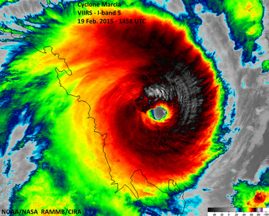
Cyclone Marcia, QLD, February 15-21 2015
-
Cyclone Wanda, QLD (Brisbane), January 20-25 1974
-
Gold Coast Cyclone, QLD, February 17-21 1954
-
Mackay Cyclone, QLD, January 20-24 1918
-
Innisfail Cyclone, QLD, March 10th 1918
-
Cyclone Mahina, QLD, before March 3-5, 1899
-
Cyclone Vance, WA, March 18-24 1999
-
Cyclone Steve, QLD / NT / WA, February 27 – March 9 2000
-
Cyclone Gwenda, WA, April 2-7 1999
-
Cyclone Inigo, WA, March 30 – April 8 2003
-
Cyclone Orson, WA, April 22-23 1989
-
Cyclone Monica, NT / QLD, April 17-25, 2006
-
Cyclone Joan, WA, November 30 – December 10 1975
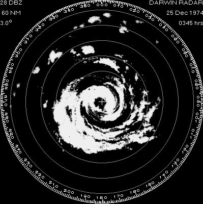
Cyclone Tracy on Darwin radar via BOM
AUSTRALIAN HISTORIC CYCLONE-RELATED FEATS:
RAINFALL:
-
Peter, 1979 – Mount Bellenden Ker 1947mm
-
Rona-Frank, 1999 – Mount Bellenden Ker 1870mm
-
Oswald, 2013 – Upper Springbrook 1443mm
-
Wanda, 1974, Mount Glorious 1318mm
-
Fletcher, 2014, Kowanyama 1250mm

Cyclone Oswald along the Tropical North QLD Coast via BOM
WIND SPEED:
-
Cyclone Olivia, 408km/h Barrow Island (likely from a tornado, but this was never confirmed)
-
Cyclone Debbie, 280km/h Hamilton Island
-
Cyclone Olivia, 267km/h Varanus Island
-
Cyclone Vance, 267km/h Learmonth
-
Cyclone Trixie, 259km/h Mardie
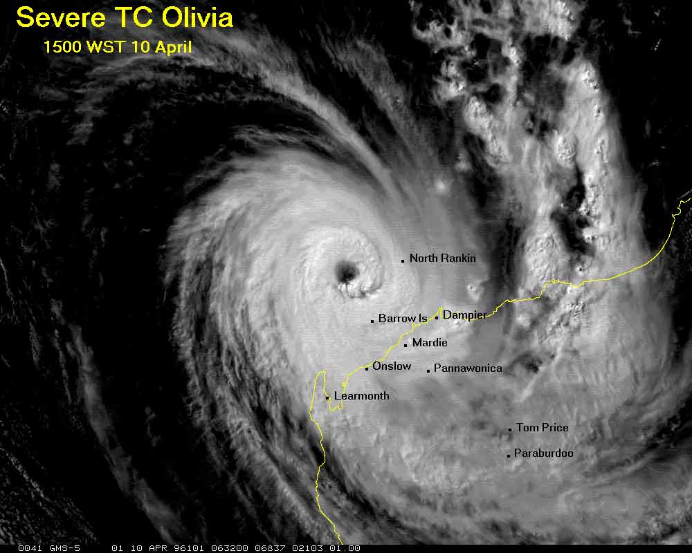
Cyclone Olivia at maximum intensity via BOM
Note: Anemometers were both destroyed in Onslow (246km/h – Cyclone Trixie) and Darwin Airport (217km/h –Cyclone Tracy), so higher wind gusts may have been recorded.
PRESSURE (No Cyclone has officially dropped below 900hpa in Australian waters, the only other place that hasn’t happened is the Northern Indian Ocean due to the close proximity to landmass):
-
Inigo 900hpa
-
Gwenda 900hpa
-
George 902hpa
-
Orson 904hpa (905hpa measured at a gas platform – lowest recorded in AUS)
-
Vance 910hpa

Cyclone Inigo at peak intensity via Emergency.co.nz
TORNADOES:
-
Oswald – At least 6 confirmed (Central Coast & Whitsundays, Wide Bay, Fraser Coast)
-
Carlos, WA – 5 (4 in Karratha and 1 in Perth)

Tornado damage in Karratha from Cyclone Carlos via Sydney Morning Herald
[/fusion_text][/fusion_builder_column][/fusion_builder_row][/fusion_builder_container]
Sorry, the comment form is closed at this time.