17 Aug Geoengineering and Chemtrails
Over the 2021/2022 calendar period, there has been a very distinct influx in curiosity by the general public surrounding chemtrails, geoeningeering, government man-made weather phenomena, controlled weather etc. A large portion of this has been brought on by a ‘want’ for understanding why continuous flood events have impacted Eastern Australia over this calendar period, and some of it has been injected into society by ‘conspiracy pages’, ‘conspiracy artist’s’ or people wanting to push an agenda for publicity.
You are currently reading this blog / article as a means for seeking our view point on this topic. Our viewpoint is VERY clear (and this can is also reiterated in our ‘about section’ on our social media platforms). We DO NOT subscribe to the theory that chemtrails is a thing. We are NOT buying into the fact that flood events during the 2021 and 2022 calendar years were man made. While we CANNOT force an opinion on you, nor can we change your mind (if you disagree with us)… we MUST request that you RESPECT our viewpoint, RESPECT our understanding and knowledge on the topic and understand that YOU have gone to the effort to view this blog or article (we havent asked for a debate on the matter). If you care to look at our scientific and logical reasoning, we have many common questions listed below along with explanations.
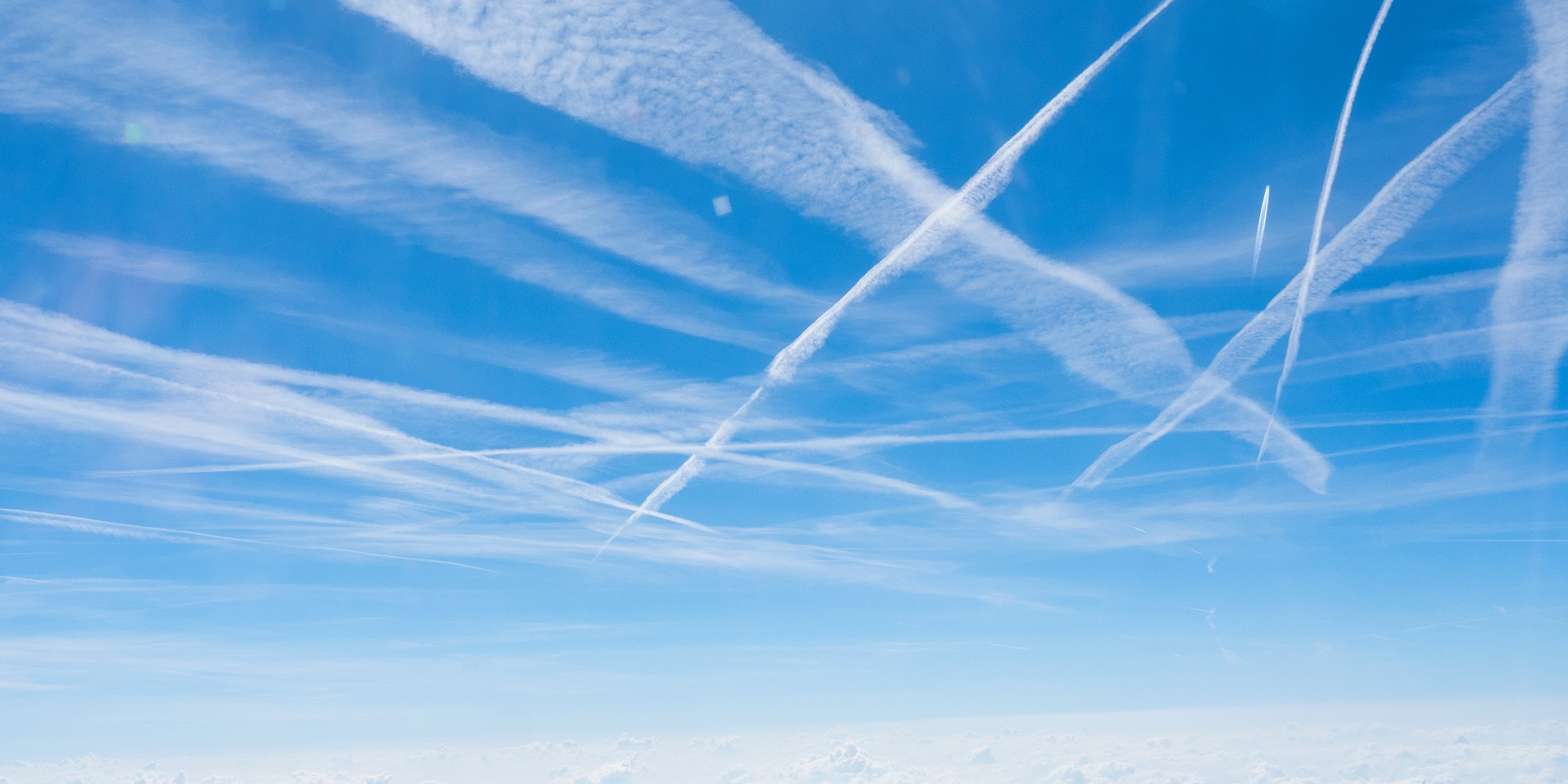
What are these lines in the sky???? They dont look natural!!
98% of the time, the answer will the same. They are CONTRAILS (not CHEMtrails) from airplanes. The other 2% of the time (and that might be a generous percentage), they will simply be cirrus clouds that happen to be in a straight, well-defined line.
When a plane is flying, it is ALWAYS producing exhaust. This exhaust however is made up of water vapour. When flying at high altitudes, these aircraft are very often in very cold temperatures (sometimes as cold as -55 or even -60ºc). Due to the extreme cold temperatures available, this water vapour in the exhaust very quickly condenses around soot which is also being extracted from the planes exhaust. This condensing feature allows for clouds to form, and they will very slowly disperse. Sometimes, the clouds take a considerable time (30mins or more, maybe even an hour or longer) to dissipate… this is based on 2 things. 1: The density of the water (if there is more water vapour available, then the clouds become thicker) and 2: the temperature available (the colder it is, the longer it takes to disperse).

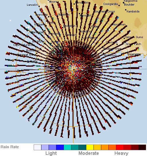
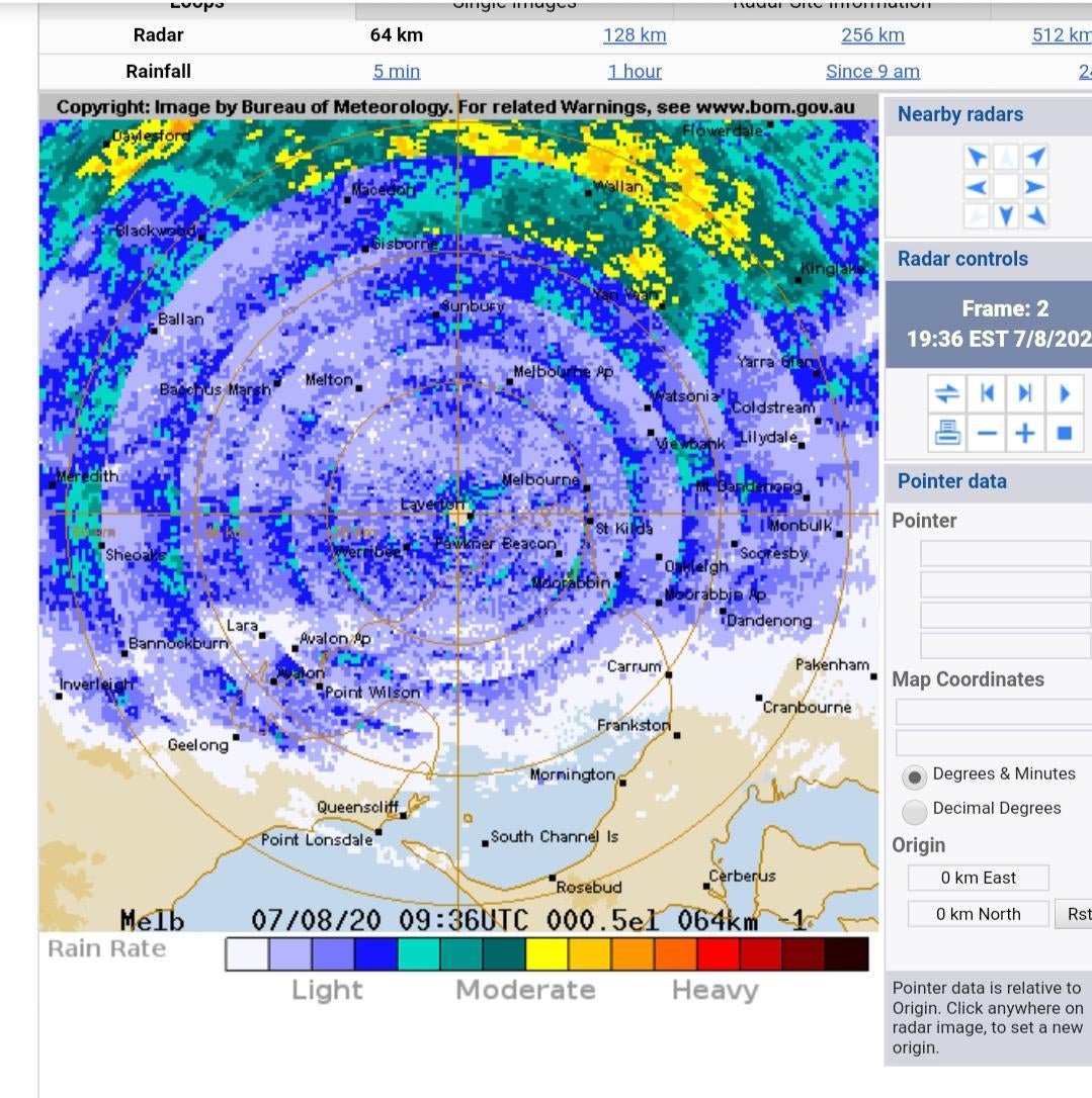
What are these lines on radar???
A very common response to us is that the straight lines on radar are a clear indication of the government ‘chembombing’ a certain location. The truth of the matter is, Australia is one of the WORST countries in the world when it comes to weather radar systems. Our radars are ANCIENT in comparison to the rest of the world, and places like Canada and America are about 20-30 years more advanced than Australia. When you look at the Bureau of Meteorology radar page (linked here: http://www.bom.gov.au/australia/radar/) – any ‘red’ triangle is a ‘standard weather watch’ radar or in simple words, it was designed back in the 1980s or 1990s and hasn’t passed enough polls to upgrade to something from at least the 21st century. Many of the radars in Australia are also what we call ‘C-Band’ which is one of the more ancient types of radar.
Before I get too deep into a rant about the poor quality of radar in Australia… what it all means is that radar is technology and technology fails from time to time (the older the technology, the more it fails, just like clocks, watches, tv’s, cars, phones etc). This means, we will see random circles, random lines, multi-coloured circles of doom from time to time.
Some radars are more prone to producing these features than others. Examples of this include:
* Moree radar being more likely to produce the random straight beam – this often occurs when there is ‘too much’ moisture around and some faults in a particular part of the radar (because its old) then misinterpret the reflectivity.
* Port Hedland & Learmonth both often has a semi circle of rain offshore – this is more common in Summer, but can happen at any time of year, and its 1 of 2 things (or both together). The first being sea clutter with ships, birds etc out at sea passing through the radar beam. The second is humidity at sea (because the sea is more humid than land) becoming trapped under a capping inversion during the evening and night and the beam is passing through the build up of moisture.
* Brewarrina, Mount Isa and Wagga Wagga are 3 of the more common radars that produce concentric circles (mostly during the evening and night in Summer). This again is moisture becoming trapped under a capping inversion during the evening (when moisture increases and the cap potentially strengthens because the temperature is cooling). It then shows up as concentric circles evenly spaced apart.
* Brisbane (Mt Stapylton) and Perth radar’s are two of the more common radars for showing weird snake-shape or s-shaped, wriggly lines moving in unison with each other. This is often chaff with several training bases nearby to these radar sites. This chaff is used in military exercises and when they are training (because everything needs training so they can perfect it when it matters), it showers up on radar. The chaff gets caught up in the upper level winds and is blown across the radar site. The direction purely depends on the winds above 500mb.
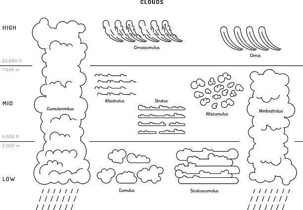
What are these weird clouds? Ive NEVER seen ANYTHING like it before!
The number of different clouds types around the globe are probably equal to the number of species of fish in the sea, or birds in the sky… it sounds like an over exaggeration but its probably not as far off as you think. There are 11 MAJOR cloud types, however these major types can then be broken down into anywhere from 3 to 8 subtypes, with these subtypes potentially being broken down further. An example of this is ‘Cirrus’ clouds. Cirrus is the MAJOR type, however cirrus can then be broken down into cirrus castellanus (rising towers, turrets), cirrus fibratus (fiberlike, hairlike clouds), cirrus floccus (puffy, ragged tufts), cirrus spissatus (dense cirrus clouds), cirrus uncinus (curved cirrus clouds), cirrus duplicatus (multilayered), cirrus intortus (interlaced cirrus clouds), cirrus radiatus (parallel bands… ie contrails), cirrus vertebrates (fishbone-like), cirrus fluctus (also known as Kelvin-Helmholtz clouds), cirrus mamma (also known as mammatus clouds), cirrus homgenitus (caused by humans… ie contrails again), cirrus homomutatus (its a cirrus homogenates that then spreads or changes shape). Chances are, without being rude, you need to look up at the sky more. There are not many clouds in the world that are ‘super rare’ and either you havent looked yet or you havent noticed yet. Dont let either of those factors start to sway your opinion about the clouds being fake. Here is a direct link to the different types of Cirrus Cloud > https://whatsthiscloud.com/cloud-types/cirrus/
One common type of cloud that often raises questions – especially when seen on satellite imagery, are ‘Gravity Wave Clouds’, or ‘Lee Wave Clouds’. The two are different, despite looking similar and having similar names. Lee Wave Clouds are more common on the ‘lee side’ or ocean side of a mountain range. You need to try and think of mountain side as something drawn on a piece of 2D paper (not 3D like reality). The wind cant go ‘through’ the mountain, it has to go over it. As the wind moves up one side of the mountain, it interacts with increased moisture which condenses and forms a line of clouds, it then pushes those clouds away from the mountain top and the process is repeated as long as the wind stays from the same direction and the moisture flow is constant. Gravity wave clouds can happen anywhere, and it is a similar process.. only this time its caused by rising and sinking air (this can be brought on by waves of pressure or fluctuations in temperature). Both are very natural, both actually don’t cause precipitation to occur as they are usually fair weather clouds.
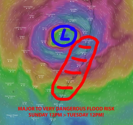
Why is it raining so much over a small area? Has the government seeded that area?
There are very few ‘guarantees’ with weather, however one that comes very close to being a guarantee are upper level lows producing rainfall. Normally people think of lows as being one single thing, however low pressure systems can form at any altitude, and where they form can lead to vastly different weather. Their speed and strength can also dictate their effects.
During the 2021 and 2022 calendar years, we have seen numerous (more than what would be considered ‘average’) upper level lows impact Eastern NSW and South Eastern QLD. A large reason for this is what we call ‘SAM’ or ‘Southern Annular Mode’ and simply when we have a negative SAM, upper level lows or rain bearing systems generated in the upper levels of the atmosphere stay further South and when we have a positive SAM, these same systems track further North. During 2021/2022 we have been stuck in a largely stagnant pattern of having a positive SAM value, this has helped more upper level lows track up across NSW and Southern QLD.
We all know how surface low’s work and how cyclones work. The winds move clockwise around the system and drive rain onto land… however you need to pay close attention to WHERE the winds are coming from. In cyclones or general surface low’s, the winds that wrap around the SOUTHERN side of the system are more likely to produce rainfall over Eastern Australia. This is because as the winds move around the system, they are fetching moisture from offshore and dragging it back over land. Winds around the West and North are more likely to be dry because they’re fetching little to no moisture from land areas. For Western Australia its the opposite, the North and North East are more likely to feel the brunt of the rain, whilst the South and South West are more likely to remain dry. The same is with upper level low’s though… if the winds with an upper level low are originating over water and feeding onto land (Southern and South West sides of the upper level low), then they are dragging moisture over these areas. The problem then arises when you have surface winds dragging moisture over these areas also… now all of a sudden you have 30,000ft, 40,000ft or even 50,000ft of moisture being filed into a small 50-100km area. This area immediately becomes a focus of potential flooding rainfall because the rain simply won’t stop until a single part of this combination is broken (the upper low moves and the winds shift, the surface flow is ceased etc). For some places, this can happen repeatedly because the atmospheric conditions are favourable…
Is cloud seeding real???
The simple answer is YES – to a degree.
Cloud seeding was part of the issue with the Tasmanian floods back in Winter 2016 when it became public knowledge that cloud seeding took place over Tasmania around 24hrs prior to a significant rain event occurring. Cloud seeding has also occurred in Winter of 2022 over the NSW and Victorian Alpine areas to help induce increased snowfall due to it being such a poor season.
We at Higgins Storm Chasing DO NOT dismiss the legitimate claims that cloud seeding has and does occur, however there is ample proof at ‘most’ government agencies have ceased cloud seeding not just in Australia, but worldwide, due to the poor performances and the cost of cloud seeding. There have been documentations on at least 50 counties trying it. The Tasmanian floods in their own right were in the minority.
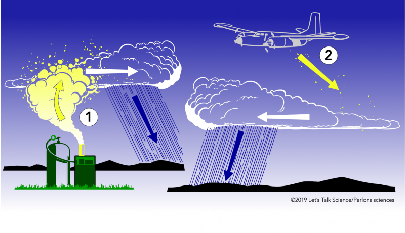
How does cloud seeding work?
Basically cloud seeding occurs when aircraft or drones carry silver iodide, potassium iodide and dry ice, and drop / dump / spray / inject that substance into clouds. The silver iodide has a similar chemical structure to ice which forms in clouds, and this allows water droplets to cluster up around the particles (which are exceptionally small / virtually invisible). This clustering allows for clouds to increase and precipitation to become ‘more likely’. For most areas, this falls as rain, however over Alpine areas and mountainous terrain… it can allow the precipitation to fall as snow. Obviously there is a massive cost for doing such things, as you are not only needing to pay for the substance and the ability to move it through the air (via countless drones and/or planes) but also the shear volume as its not a simple task of ‘seed here and it rains here’.
There is very little evidence to support any claims that cloud seeding worsened the 2021 or 2022 floods across Central Eastern NSW, North Eastern NSW or South Eastern QLD. As stated above with the explanation of how upper level low’s work.. these areas were subject to very slow moving upper level low pressure systems which caused several days of rainfall. Cloud seeding or no cloud seeding, these areas under these conditions were ALWAYS going to see substantial rainfall accumulations. One factor for claiming there is very little evidence to support such claims is the fact that numerous global weather forecasting models predicted the rainfall which occurred, accurately. Whilst you can claim that governments can seed and alter how much falls, they wouldn’t be able to locally alter the mathematics and physics behind how weather model data is derived.
Is Higgins Storm Chasing being paid by the government to keep quiet??
The direct answer is no. If we were getting paid we havent seen any of the money yet (this is sarcasm). No we aren’t keeping quiet about anything. Everything listed in this article is not only our belief, but backed up by scientific data. We have nothing to hide and we simply aren’t interested in hiding anything. We provide a reputable service for our loyal customers and followers where we forecast the weather for the coming days, we monitor the weather on the day, we provide warnings from both our vast experience and knowledge to help people and we share content from not just ourselves, but our loyal followers that show what is happening with the weather in their area (whether its good, bad or indifferent). We dont have the time, resources or care to hide anything.
Sorry, the comment form is closed at this time.